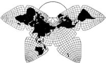
Cahill 1909
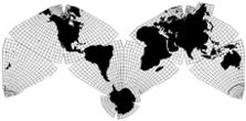
Cahill-Keyes 1975
|
Cahill 1909
|
Go back to
Gene Keyes home page
Cahill-Keyes 1975 |
|
Why Cahill? What about Buckminster Fuller?
Evolution of the Dymaxion Map: An Illustrated Tour and Critique Part 6 by Gene Keyes 2009-06-15 Summary: I
love Bucky, but Cahill's map is a lot better. Here's
how.
CONTENTS Click inside boxes to open other sections in separate windows. |
|
Part 6
Later Editions and Large World Game Versions After 1954, the icosahedral Dymaxion Map may have
languished; I am not aware of any subsequent editions until
1967, when Honeywell Inc. purchased the rights, and issued
both a wall map of 1/48,000,000, and a cardboard punch-out version
which could be folded into an icosadron of about 16 cm (6.5")
in diameter, with a scale of about 1/77,500,000. (The smaller fold-up
model is mistakenly labeled with same scale as the larger wall
map.)
The Honeywells have the same underlying artwork as the Raleigh, except for color changes: replacing Raleigh's ugly grey oceans with blue, and somewhat different color tints for the same temperature-gradients Fuller has always emphasized. For the next quarter century, until the 1980 Grip-Kitrick (see further below), the Raleigh chassis was the only basic rendition of Fuller's icosahedral. |
| Fig. 6.1 below:
The Honeywell edition of the foldup icosahedron Dymaxion Map
model, later renamed The Creative Edition, later renamed The Millennium
Edition Spaceship Earth. Still available from Buckminster Fuller Institute. |
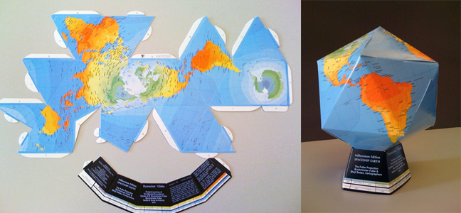
Source: Buckminster Fuller Institute
http://bfi.easystorecreator.com/images/Fold-Up-Globe_large.jpg Note: Images of all the individual
facets are shown in Part 9.
|
|
Fig. 6.2 below: Black-and-white illustratioin
of the Honeywell Edition; see color version below.
|
Source: scanned by Gene Keyes from p. 113 of R. Buckminster
Fuller,
50 Years of the Design Science Revolution and the World Game (Carbondale: Southern Illinois University; prepared for Joint National Meeting of the Operational Research Society and American Astronautical Society, Denver, Colorado, 17-21 June 1969) |
|
Fig. 6.3 below: Fuller later retrieved
the rights from Honeywell; in fact, my own copy of the ex-Honeywell wall
map has a sticker pasted over its previous Honeywell imprint. Among the
many Internet images of the Dymaxion Map, I have not seen the Honeywell
wall version on the Web. Here is as much as I can scan, focusing on Eurasia
and its China-Korea "problem zone" mentioned below, and discussed in greater
detail in my critique, Part 9.
|
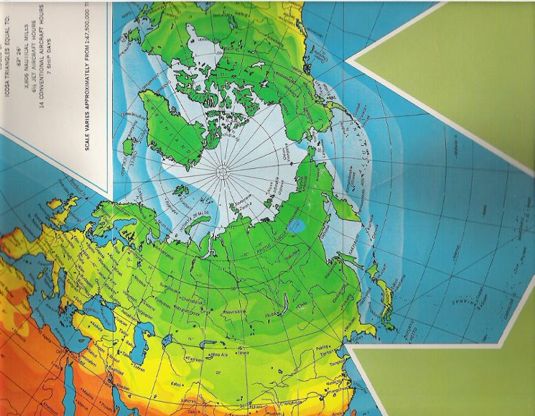
Source: excerpt scanned by Gene Keyes from personal copy, and adjusted (at least on my monitor) to its actual triangle-edge length of 147 mm, and original scale, 1/48,000,000. R. Buckminster Fuller and Shoji Sadao, Cartographers © 1954, 1967 by Buckminster Fuller |
|
Fig. 6.4 below: In 1972, the Bank of Nova
Scotia also issued a printed wall-map version, with whole
triangles (see also Fig. 6.5 below), but with
distracting heavy black lines between them, and Antactica split.
Otherwise, it uses the same basic artwork as the Honeywell 1967 version.
However, those black lines are not merely darker icosahedral edges,
but actual separation of the triangles from one another.
I won't scan the whole thing, its size being 53 x 88 cm (21 x 35"). However, I am again showing its treatment of the "problem zone" of all Dymaxion icosahedral maps, namely the dislocated area between China, Korea, and Japan, especially the Bohai Sea and Yellow Sea. I will have more to say in Part 9 about this.. For me, it proved to be the decisively fatal flaw of the Dymaxion Map. |
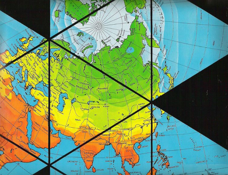
Source: excerpt
scanned by Gene Keyes from personal copy, and adjusted
(at least on my monitor)
to its actual triangle-edge length of 147 mm, and original scale, 1/48,000,000. R. Buckminster Fuller and Shoji Sadao, Cartographers © 1954, [1972] by Buckminster Fuller |
|
Fig. 6.5 below: This is a 1972 magnetic-tile
version of the Dymaxion Map, issued by The Bank of Nova
Scotia; set in a black-metal frame, 20 x 23 cm (8 x 9"). The
"refrigerator-magnet" triangles are about 35 mm (1 1/2") on
a side, scale 1/200,000,000. At least we have 20 whole triangles
here, not those silly splits. The southwest tip of Australia could
be restored with a small overhang annex, and South Korea and Japan
could likewise be restored with a similar annex. None of these would
require dividing a triangle, but simply repeating some land area where
it belongs.
|
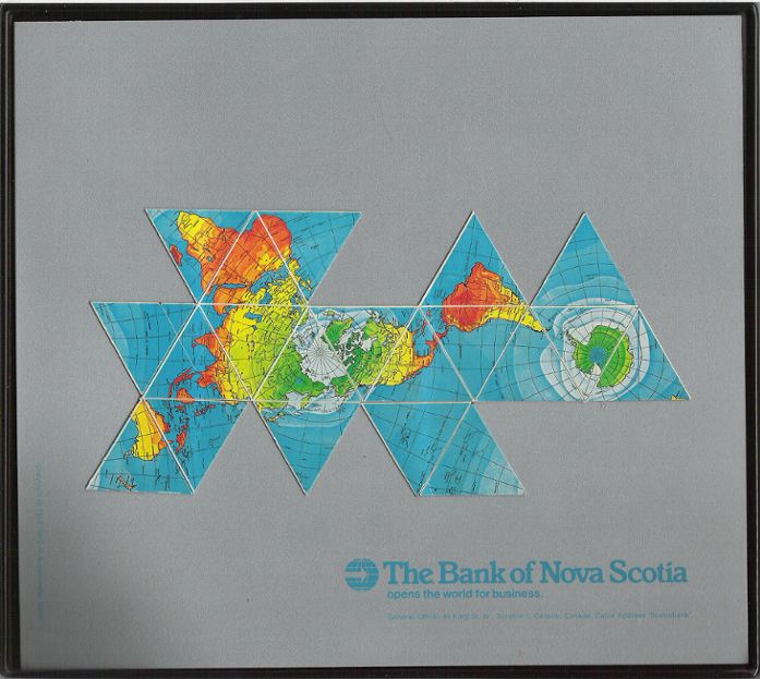
Source: scanned by Gene Keyes from personal copy
for this page, 2007-04-07.
R. Buckminster Fuller and Shoji Sadao, Cartographers © 1954, 1972 by Buckminster Fuller |
|
Fig. 6.6 (below): Here is a larger wall
size map with the same temperature zone colors as the Honeywell
artwork. I do not know if this is a one-off, custom print, but
it appears to be the same scale as the 1/20,700,000 black-and-white
outline maps used in pilot projects for the World Game. (See Fig.
6.8.) In picture, Thomas Zung, (left), and Bill Perk (right).
|
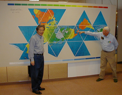
Source: http://www.buckysdome.org/img/album_exhibit_2.jpg
|
|
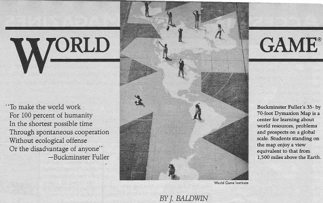
Fig 6.7 (below): In 1964, Buckminster Fuller
advanced the idea of a “World Peace Game”, or “World Game”,
in which participants would do simulations of global trends,
and propose alternate scenarios of rapid economic success for
everyone on earth, without human exploitation or environmental
damage.
In its most grandiose formulation, there was to be a giant computerized globe flattening to a football-field sized Dymaxion map, to display the resources and results. (This was Fuller’s proposal for the U.S. pavillion at Expo 67 in Montreal; but the U.S. only accepted Fuller’s now famous geodesic sphere, to house a much more trivial exhibit.) Small pilot projects of the World Game were launched in 1969 in New York, then at Southern Illinois University, Carbondale (this is where I came in). The first exercise was at New York Studio School of Painting and Sculpture in the summer of 1969. Here the backdrop was a large wall map made of triangular metal panels, plus clear vinyl overlays. I have seen this one, but do not know its scale: possibly ca. 1/13,000,000. |
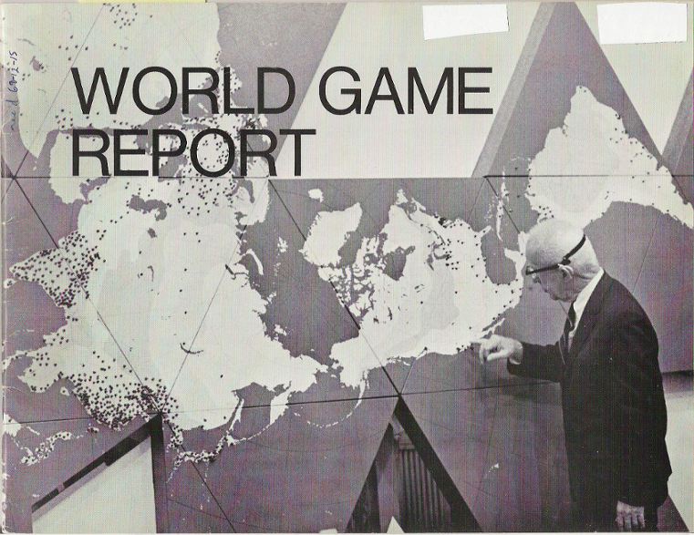
Source: scanned by Gene Keyes from cover of
World Game Report, [28 p.], ©1969, Edwin Schlossberg Photography by Daniel Gildesgame and Herbert Matter. |
|
Fig. 6.8 below: Somewhat smaller 3’ x
6’ paper maps were the main visual tool later in 1969 at Southern
Ilinois University, Carbondale (SIU): large, but not quite
the football-field size digital display. This excerpt from a
black and white outline undated map [1967?] also appears to have
the basic Honeywell data, without color layers. (See Fig. 6.6.)
It is the largest printed version I know of, ca. 1 m x 2 m, or 39" x
77",); 1/20,700,000. These were used when I participated in early versions
of the World Game at SIU, 1969-70. As above, I am focusing on the
"problem zone", where Korea is dislocated away from the from the
Chinese mainland, and the Bohai Sea is dilated. (Pencil marks are
mine.)
|
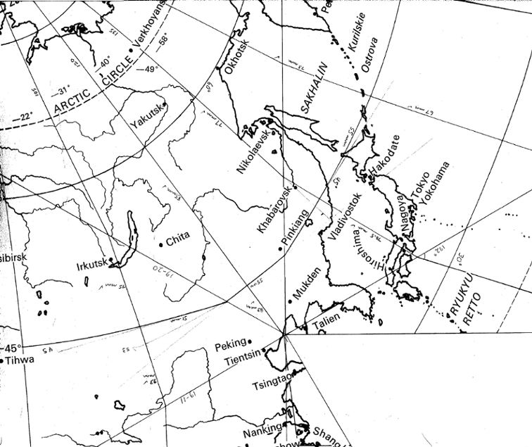
Source: excerpt scanned by
Gene Keyes from personal copy,
and adjusted (at least on my monitor) to its actual triangle-edge length of 340 mm, and original scale, 1/20,700,000. R. Buckminster Fuller and Shoji Sadao, Cartographers © 1954, 1967 by Buckminster Fuller |
|
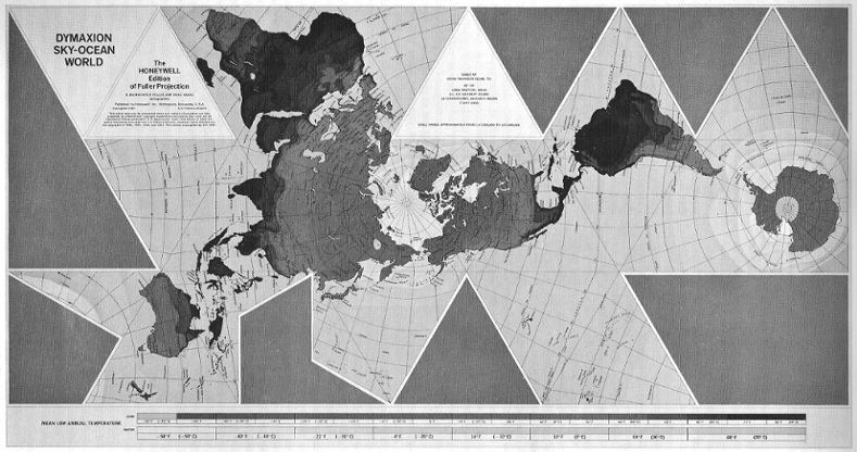
Fig. 6.9 below: In 1980, Rob Grip
and Chris Kitrick produced a much more mathematically precise
rendition, almost as big as the outline map above, at the scale
of 1/21,000,000. This one avoids nicking the Shandung Peninsula,
and avoids dilating the Bohai Sea (see Fig. 6.8 above),
but still leaves Korea and Japan yanked upwards by 60º away
from the Yellow Sea and Chinese coast.. The coastlines and rivers
are finely-drawn, but no points on the map are identified, not even
the lines of latitude and longitude: which are one-half
degree. I have longed for world maps with geocells of one
degree, accentuated at five, but an anonymous half-degree grid overshoots
that mark, and still prevents any comparison to a globe or other kind
of world map. For a more detailed analysis of the Grip-Kitrick map, see
Part 9.2.
|
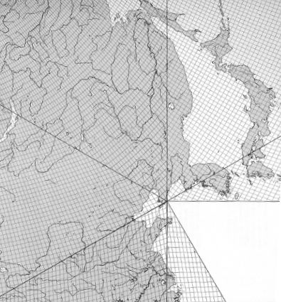
Source: excerpt scanned
by Gene Keyes from personal copy,
and adjusted (at least on my monitor) to its actual triangle-edge length of 335 mm. and original scale, 1/20,700,000. Dymaxion Sky-Ocean World, Grip-Kitrick Edition of Fuller Projection © 1980 by Buckminster Fuller |
|
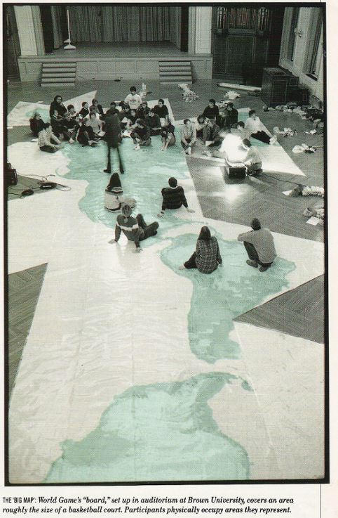
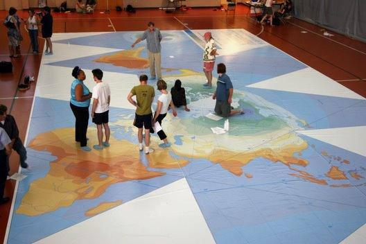
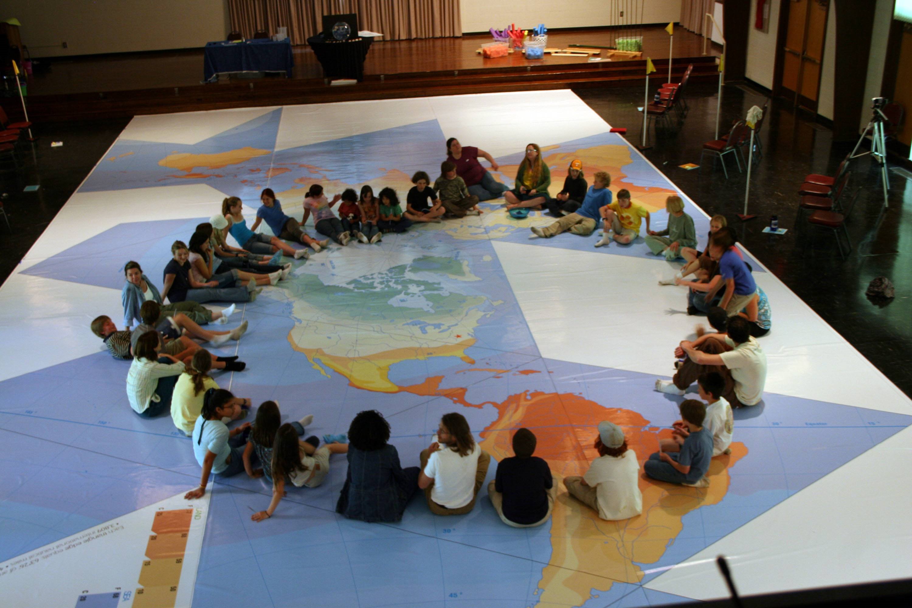
Medard Gabel was a principal lieutenant of Fuller’s
at Southern Illinois University, and went on to co-found the
World Game Institute in Philadelphia 1972. It led group sessions
with dozens of players at a time in many locales, and over 24,000
participants. In 1982, the Institute at Fuller’s behest produced
a 1/2,000,000 Big Map (see below), which became the gymnasium-floor
venue wherever the World Game was played.
In 1992 I attended one of their four-hour World Game sessions at Dalhousie University, in Halifax, Nova Scotia. The simulation was enlightening, but I was disappointed to see that the Big Map was a taped together patchwork of unmatching sheets of the 1/2,000,000 JNC (Jet Navigation Chart). Being two different Lambert Conformal conical projections, plus a Transverse Mercator, the various sheets diverge from one another. Although quite an accomplishment, this map is not a Dymaxion projection, but only a bunch of ordinary maps stuffed into a Fuller-icosahedral frame. Nonetheless; I've been quite envious of the Big Map, since I have long wanted to produce an octahedral at twice that scale: see here and here. B.J.S. Cahill as early as 1912 had proposed massaging together the conically diverging sheets of the 1/1,000,000 International Map of the World [IMW] into a single floor-profile of his Octahedral Butterfly Map. [Click here (smaller) and here (larger) for diagrams.] He even made a detailed proposal to the Griffith Planetarium in Los Angles for this, but it was not implemented. |
|
Fig. 6.10 below: The "Big Map" used
by the World Game Institute in the 1980s and 90s: this at
the World Future Society's 1982 General Assembly. Standing
in center is Buckminster Fuller; at right, Medard Gabel. No
Dymaxion graticule is on this map, it being a taped together patchwork
of conventional Jet Navigation Charts, at 1/2,000,000. Ian MacFarlane
converted the JNC charts, with advice from Chris Kitrick and Brent
Seville.
|
|
For a smaller picture size, click in it
once; to restore enlarged size, click in it twice.
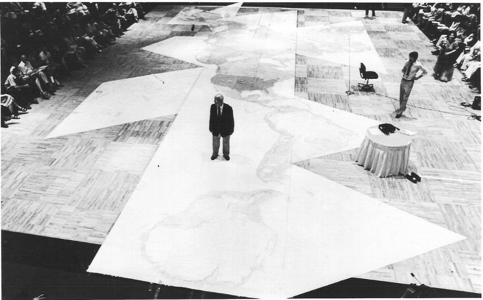
Source: scanned by Gene Keyes in 2009-04 from a photo received in 1983-05 from the World Game Institute |
Here is a description of the
map from a product sheet I received in 1983-04 from the World
Game Institute: Big Map. World Game edition of the Dymaxion Map, 70 feet by 35 feet at one to two million scale. Surface data from U.S. Air Force navigation charts. Large and small rivers, lakes, major railroads, highways, cities, towns over 5,000 people, elevation, airports, etc. are displayed in three colors. One inch equals 32 miles. At the 1:2,000,000 scale, the world's jet airplanes fly at only 1/4 of an inch above the surface of the 70 foot long world map. The space shuttle goes into orbit at ankle height. The highest and lowest points on Earth -- Mt. Everest and the deepest ocean trenches -- are only 3/16 of an inch above or below the paper surface of this map. Standing on the map the world appears as it would if you were 2,000 miles above the surface. At this scale, the moon is at the height of a 70 story building, and the sun is 25 miles away. Walking about on this giant map, as Buckminster Fuller says, "human beings can sense their hometown, not only in relationship to the whole undistorted display of the one whole world, but in scale with the surrounding celestial bodies. People can feel themselves in an entirely new cosmic orientation." Includes clear vinyl protective cover. $12,000. In 2000, the non-profit World Game Institute
sold its assets to a commercial successor called o.s.Earth
Inc., whose website now appears to be moribund. I am told that
the former World Game Institute had produced eight or nine such maps,
but that o.s.Earth, due to transport costs, declined to use them,
or much of anything else related to Buckminster Fuller and his ideas.
|
|
Fig. 6.11 below: Another
picture of the Big Map, this from an article by Craig Lambert,
"Bucky Fuller's Big Game Goes On" (World Monitor, 1989-06)
p. 18-20. Lambert reported that in the two decades as of then,
24,000 players had "made the world work without war".
|
Source: scanned by Gene Keyes, 2009-04, from
World Monitor,
1989-06, p. 19 |
|
Fig. 6.12 a & 6.12 b
below: A photo of the Big Map which shows how it comprises
an irregular patchwork of JNC charts. In the second frame below, Fig.6.12
b, notice the various division lines within foreground triangles.
(The scene is a public event when a commemorative stamp in honor of Fuller
was issued, 2004-07-13.)
The first frame is the whole picture, reduced to 19%. The second frame is a foreground excerpt, at 100% (Original picture is a megabyte, so I am not including its full size on this page, to avoid slowing the page-load. However, click here to open entire image in a separate window in all its oversize glory.) Source: http://www.geni.org/globalenergy/projects/news/whats_new/bucky-
commemorative-stamp-event2004-07-13/photos-by-pmdekker/100_0440.JPG (if using this URL, delete space at line-break) |
Fig. 6.12 a: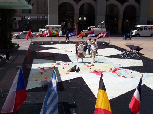
|
Fig. 6.12 b: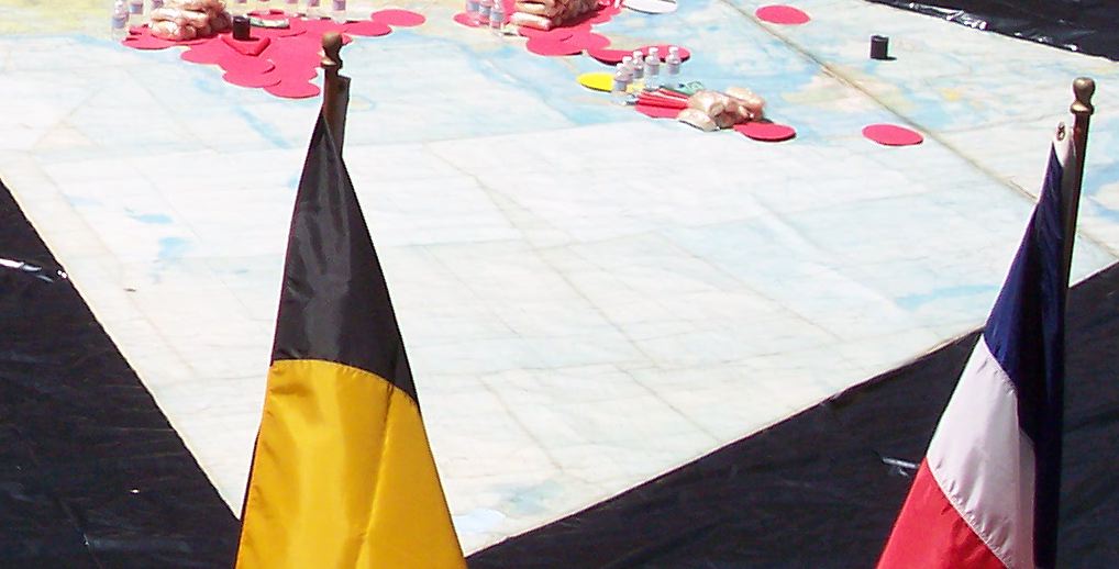
|
|
Fig. 6.12 below: A later version developed
by the World Game Institute was the "Playground Map" at the same
1/2,000.000 scale, using the JNC composite as a template. However,
this one only has continental silhouettes. Stencils and curriculum
materials were made available to schools around the country.
|
Source: scanned by Gene Keyes from Whole Earth Review #68, Fall 1990. Baldwin's article, without pictures, is online at http://findarticles.com/p/articles/mi_m1510/is_n68/ai_8897888/?tag=content;col1 |
|
Fig. 6.13 below: The same picture as
Fig. 6.12 above, in color, was previously on the
o.s.Earth website, but without description.
|
Source: downloaded by Gene Keyes from osearth.com in 2008; no longer there in 2009. |
|
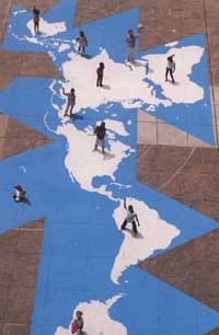
Fig. 6.14 below: Another descendent of
the World Game concept is a North Carolina educational project called Earth
Voyage. This too uses a floor map that appears to be the same
size as the JNC Big Map, but re-created as a simpler version
of Bucky's original temperature-gradient icosahedrals, with little
detail other than the temperature colors, and the 15 degree graticule.
Though impressive in their own right, I regard this and the "Playground
Map" more as set decorations, than as globe-comparable maps complete
with 1º meridians and parallels and names and places and countries.
|
Source: http://earthvoyage.googlepages.com/home |
| Fig. 6.15 below: A different
view of the Earth Voyage map: |
|
For a smaller picture size, click in it
once; to restore full size, click in it twice.
 Source: http://earthvoyage.googlepages.com/home
 |
| Another view of this map, a flat
Internet image, is at the end of Part 7, Fig. 7.14. |
|
Like much other previously hard-to-find material,
Dymaxion maps benefit from the advent of the Internet, making them far
more readily available than in earlier times. This set of web pages is
a case in point; and next, it gathers some examples of Fuller maps to be
found in cyberspace.
|