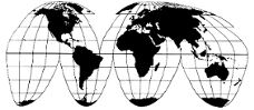
Cahill 1909
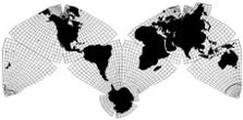
Cahill-Keyes 1975
|
Cahill 1909
|
Go back to
Gene Keyes home page
Cahill-Keyes 1975 |
|
Why Cahill? What about Buckminster Fuller?
Evolution of the Dymaxion Map: An Illustrated Tour and Critique Part 1 by Gene Keyes 2009-06-15 CONTENTS Click inside boxes to open other sections in separate windows. |
|
Part 1
Introduction and Background Notes Since 1961 I have been a devotee and student of R. Buckminster Fuller (1895-1983): the noted geodesic dome inventer, architect, designer, futurist, philosopher, and great helmsman of Spaceship Earth. In particular his "Dymaxion World Map" had caught my attention back then for its feat of showing all continents uninterrupted and with minimal distortion. When I resumed college studies in 1969, I chose Southern Illinois University, Carbondale, in part because it was home base to Fuller, who was loosely affiliated with its Design Department. (Most of the time Bucky was lecturing elsewhere around the world.) I participated in early versions of his "World Game", and created a Special Major of "Government: War-Peace Studies" to include Fuller's perspective in my world politics curriculum. (Hat tip to H.F.W. "Bill" Perk, my teacher there, who carried on Fuller's legacy at SIU.) For the World Game, we used wall-size outline versions of the Dymaxion Map, ca. 1 m x 2 m, (over 3' x 6'); 1/20,700,000. I acquired some more of those and others, and went on to study them in minute detail. In 1973 my (international relations) M.A. thesis at Southern Illinois University was entitled "Six Principles for a Unified Map System (Applied to the China-Russia Situation)" (213 p. + 49 maps). In it, I not only celebrated the Fuller projection, but also adopted it as the base map for the System being proposed in that thesis. Then I discovered B.J.S.Cahill's 1909 Octahedral Butterfly World Map: and found, after a lot more study, that Cahill had already accomplished Fuller's whole-earth map principles, a lot earlier, and with much greater elegance. Cahill had all the continents unbroken, and with minimal distortion, in a design of perfect symmetry, interchangeable with a globe. I elaborated that appraisal in a 46-page paper in 1975, entitled "World Maps, World Politics, and World Vision." as part of my Ph.D. Comprehensive Exams at York University in Toronto. It was accepted for publication in an International Studies Association journal International Studies Notes [now defunct], but then the editor reneged; and lost the manuscript and its original illustrations. (I still have the Xeroxes.) Meanwhile, I had to focus on my dissertation (1975-1978), and temporary positions as Assistant Professor of Political Science at Brandon University (1978-80) and St. Thomas University (1982-83). I made a nine-day visit to Cahill's archives in 1983; and until 1984 did a lot more work on Cahill. I also computed and executed a re-design of Cahill's octahedral map (modestly named "Cahill-Keyes"), with certain improvements, and adapting Fuller's projection concept into it. But exigencies arose which put the project in mothballs until my recent retirement, and launching of this website. The 46-page essay needs to be updated. Meanwhile, I am posting its precis in the appendix below to provide a context for my critique of Buckminster Fuller's Dymaxion World Map, as compared to B.J.S. Cahill's Octahedral World Map. My purpose here is not to diminish Fuller, but to show that if Cahill had already made a better map than such a visionary as Bucky, it is a feather in Cahill's cap, not a demerit for the Dymaxion. Fuller's map was a milestone toward the invention of the geodesic dome: achievement enough. But his map is a poor teaching tool which does not match well with a globe, and that is where Cahill succeeds. In this presentation, besides showing the Dymaxion map in all its stages since 1943, I will fault it on the following points, none of which afflict Cahill:
In particular, I will be emphasizing the importance of a 1° or at least 5° graticule (latitude-longitude grid) for world maps and globes, because this provides the most direct basis of comparison between map and globe. Fuller’s coarse 15° graticule hides its flaws; whereas Cahill’s map looks fine at any degree of resolution. |
|
Fig. 1.1 below: Here is a rare example of
a world map with a 5° grid — in fact, two maps: a Mercator, and an
orthographic globe. Unfortunately, the grid does not go onto the land masses,
nor farther toward the poles on the Mercator, only reaching 75° N or
S.
|
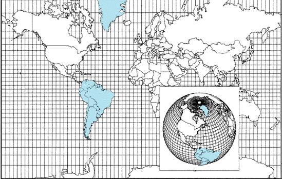
Source: http://content.answers.com/main/content/img/
McGrawHill/Encyclopedia/images/CE404400FG0010.gif [delete line-space-break if using URL] Enlarged to 105% by Gene Keyes to 1/200,000,000. |
|
A century ago, in 1909, Cahill was among the first
to denounce
the Mercator map for its widespread mis-use in schools and in general
— a mockery of its navigational purpose. But even today in the
Internet age, Mercator and its ilk continue their merry way, mis-informing
minds everywhere. Just to take one example: all Google maps begin
with Mercator. What . . . !
Map-design-seekers are often asked: for what purpose do you want to use it? The conventional wisdom is that you must go with many different projections. Cahill begged to differ, and I concur: I want a single, general purpose, world map projection, with high fidelity to a globe, suitable at all scales from smallest to largest, good for one country or the whole planet. I want a world map and globe as a synoptic pair, comparable to each other at a glance, or in detail. I want geography learners at any age to be able to grasp the globe and world map as readily as do-re-mi. By these criteria, Fuller falters; Cahill excels. |
|
Appendix
Gene Keyes Political Science Department, York University, Toronto 1975-04-20 [Cover page:] WORLD MAPS, WORLD POLITICS, AND WORLD
VISION
An Appreciation of B.J.S. Cahill (1866-1944) plus remarks on William Archer R. Buckminster Fuller John Paul Goode The human intellect, organizing, order-bringing, must enlarge itself so as to embrace, in one great conspectus, the problems, not of a parish, or a nation, but of the pendant globe. [Precis, slightly revised 2009-06-01] Part I reports the dismal results of map tests
I gave in a world politics class. The students'
warped awareness of simple geography is symptomatic
of the grossly distorted world maps to which we are all constantly
exposed, and which this paper condemns as one cause of ubiquitous
geopolitical ignorance. Especially deplorable are Mercator,
and Goode's Homolosine.
Part II is an appraisal of B.J.S. Cahill (1866-1944) as a neglected genius of world map design. His elegant octahedronal "Butterfly" map (1909 et seq) refuted the myth that a plane surface cannot show a reasonable likeness of the continents as on a globe. J.P. Goode (1862-1932) praised the Cahill map, but later (1923) produced a travesty, the now commonplace Homolosine. This paper analyzes the Cahill world map, and traces its history, early acclaim, and ultimate eclipse by misbegotten rivals. It renews Cahill's unmet challenge to judge the map against any alternative. One such is Buckminster Fuller's 1943/1954 "Dymaxion" map, a noteworthy but awkward design. Although strongly influenced by.Fuller's worldview and mapwork, this paper lauds the felicity of the Cahill model over Fuller's, using seven criteria: symmetry; graticular regularity; non-distortion of Korea; scalability; metric measurement; fidelity to globe; and teaching-tool learnability. Part III discusses the stultifying effects on world order thinking caused by anachronistic maps, mostly Eurocentric peepholes, or open-ended Goode aberrations and Mercator absurdities. It cites the Sprouts, Fuller, Cahill, and others, and quotes from a long-forgotten 1912 book by William Archer, The Great Analysis: A Plea for Rational World Order which is a whole-earth manifesto so prophetic it could have been written next week. The import of Cahill's map is that, even better than Fuller's, it can foster a corrected, balanced, and closed-system image of the total planet. The paper concludes by presenting a refined version of the Cahill Butterfly as the basis of a "Coherent World Map System" whose progenitor would be a proposed 1/1,000,000 "Mega-map", a master portrait of the earth in an area 40 meters long (132'). This chart and its derivatives could help renovate geography teaching, and provide a common canvas for world history and world order studies.
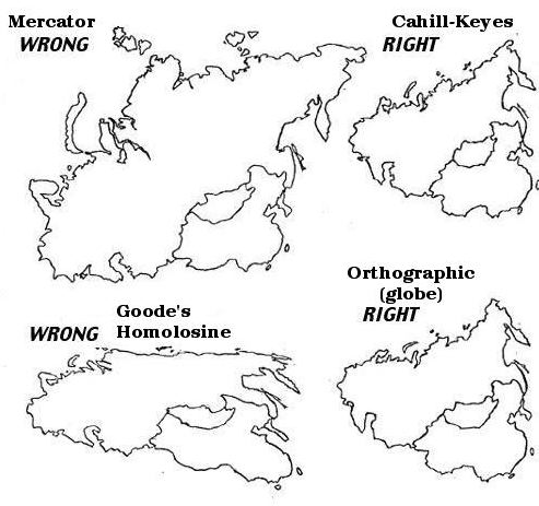
Source notes: Cahill (@7 /1/2°;
see Part 9.1);
Goode (@20° and 10° at poles) : http://atlas.nrcan.gc.ca/site/english/learningresources/carto_corner/goode.gif Fuller (@0°): Education Automation, p. 2 (See Part 9.1) Cahill-Keyes (@5°): drawn and © 1975, 2009 by Gene Keyes All four reduced to 1/500,000,000 by Gene Keyes [One of the illustration pages] FOUR PROFILES OF THE USSR AND CHINA
|
|
|
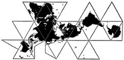
The exposition begins with Fuller's original 1943
Dymaxion map as published in Life magazine.
|