| Dr. Gene Keyes [then] Asst. Prof., Political Science St. Thomas University Fredericton, New Brunswick E3B 5G3 [currently] Berwick, Nova Scotia B0P 1E0 |
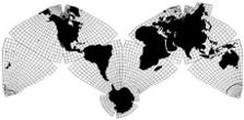
Cahill-Keyes "Real-World" Map (c. 1975, 2009) |
Geocells and the Megamap
© 1983-05-07 by Gene Keyes
2007-03-31, Abstract, and update postscripts added
2009-11-07, reformatted, updated, and illustration-links added
2009-12-30, Added this link to "Photos of the Cahill-Keyes Megamap Prototypes"
2012-03-23, Added these links:
| 2013-09-19, Added two new links: and
|
Originally presented at Canadian Learned Societies Annual Meeting:
Planetary Association for Clean Energy, 1983-06-02
ABSTRACT: Broaches the concept of "geocell", one degree of latitude and longitude, as a design criterion for world maps and globes in general, and for a proposed 1/1,000,000 "Megamap" in particular: a single frame conspectus adapting B.J.S. Cahill's octahedral projection. Emphasizes proportionality of geocells in the Cahill-Keyes variant.
A geocell is
herewith defined as an area bounded by one degree of latitude and longitude.
The earth-orb has 64,800 geocells. Most are quadrilaterals, but the 360
surrounding each pole are trilateral. Their length is constant; their width
varies. A geocell is nearly square at the equator; narrows to a spike at
the poles.
Globes and maps usually show geocells—but in combinations that vary widely from item to item: e.g., 15 x 15º, 2 x 4º, etc. Till now, so elementary a terrestrial unit as 1º x 1º has gone unnamed. And the lumping of geocells in any map has been a haphazard detail.
A meticulous one-degree world map or globe would depict all parallels and meridians, and all 64,800 geocells (except perhaps for 1º x 5º geocells within five degrees from the poles). I have never seen or heard of an entire world map or globe drawn to one degree. The Megamap described below would be the first to incorporate all geocells.
Most commercial globes, typically twelve inches, show 15º intervals. A few European products have 10º. Even big showpiece globes lack a full set of geocells. FDR's 50-inch globe, now in the Library of Congress, only has 5º geocells. The National Geographic Society's 11-footer in its Washington headquarters, is but a blow-up of its 15º twelve-inch model.
Likewise for complete world maps: generally 15º, sometimes 10º, seldom 5º; and 1º—why bother?
There is an obvious reason why a one-degree world map or globe may heretofore have seemed impractical: the traditional division of labor between notoriously distorted world maps (or unwieldy globes), and highly precise localized charts. If you want a rough—a very rough—idea of what's where on earth, you check a world map. If you want a more exact idea about the ebb and flow of Mideast boundaries, then you examine a sectional sheet or atlas, likelier to be at the one-degree level.
There is also a subconscious reason, so to speak, for the nonexistence of one-degree world maps and globes. A one-degree resolution in most world maps would more vividly expose their un-realism, their gross exaggerations: their abuse of geocells transformed beyond any compatibility with a globe: if there was a one-degree globe to compare them with!
Even without a one-degree globe, the deformations would be conspicuous. For, despite their variable width, all geocells are of the same length, mesh, and alignment. Bloat, stretch, and contortion would betray themselves all the more visibly if commonplace world maps were drawn to 1º. Many, many cancerous geocells would be conspicuous next to their more accurate neighbors.
Furthermore, imagine an ordinary world map enlarged to 1/1,000,000—say, to an equatorial length of about 40 m (132'). Imperfections, and geocell distortion, which go unnoticed—and undepicted—in book size and wall size world maps would become intolerably grotesque if seen at the larger scale. Ergo, it just isn't done. Not at 1/10,000,000, much less 1/1,000,000. At these scales or larger, you must go to a provincial atlas, or separate national sheet-map series, or the non-integral sheets of the 1/1,000,000 International Map of the World (IMW).
The conclusion we draw thus far is this: the word "geocell" did not exist in either geometry or cartography, and its lack was symptomatic of the inattention to that degree of resolution in world maps (as well as globes).
In the lengthy course of designing and drawing the one-degree Megamap 1/1,000,000, I determined that a prime desideratum must be overall proportionality of the geocells—proportionality to the adjoining ones and to the network as a whole, and to a corresponding globe with all 64,800 geocells.
I say proportionality. Of course, by nature, geocells on a sphere and a flat map cannot be identical. In the Cahill-Keyes "Real-World" Map, the equator and two meridianal great circles (20 & 110 W, etc.) match the scale of a hypothetical counterpart globe. All other meridians and parallels are progressively and proportionately shorter toward the center of the octant. I.e., all of the geocells have a specified amount of shrinkage vis-a-vis their global parent—but none of them is out of keeping with any other geocell on the globe, nor in adjacent ranks and files, nor anywhere in the entire map.
I make that statement as an artistic fact, not a geodetic one. The map is not accurate enough, thank goodness, for artillery fire or missile trajectories. But the map design, and my computation tables to four decimal places for all 64,800 geocells—their length, their width, and their x,y coordinates—are accurate enough to enable work to proceed on creating this largest of all world maps, this progenitor of the Coherent World Map System, this Megamap in a single frame, 20 x 40 m (66 x 132').
Indeed, the tables could be used for a 1/100,000 version ten times longer, if there was a site for it; or a 1/10,000 ground plan for a "Fair World World Fair" or theme park 2 x 4 km. Except for the 1º x 5º geocells around the poles, the Megamap would contain in eye-pleasing array every single geocell on planet earth, and every single continent in uninterrupted entirety and in reasonable fidelity to those same profiles as seen on a globe.
But that too is an artistic as well as a scientific judgment. To flatten a sphere, we must either stretch or shrink its surface differentially. The trade-off in the Megamap is its compression. Nonetheless, I aver that the Cahill-Keyes "Real-World" Map bears a better isomorphism to a globe than any other integral world map. And I invite skeptics to account for the size and disposition of every geocell in their alternative.
All the continents share the shrinkage—some vertically and more horizontally—but not to an inordinate degree. Instead, every 1º geocell is in good shape, present and accounted for, in well-tempered collocation, none grossly at odds with any other geocell in the big picture.
To summarize: the design for a single world map of unprecedented size has required a singular re-focus on an unappreciated (and previously undesignated) basic unit of mapping, whether plane or planet: namely. the geocell, one degree of latitude and longitude. It is the fine-tuned proportionality of a total geocell assemblage which enables the Megamap to serve both as a giant exhibition conspectus of the whole earth, and as the selfsame source of any partial or complete map at smaller or larger scales.
| Illustration-Addendum
2009-11-07: For an early diagram of the Megamap at 1/100,000,000, with 5º geocells, click here. For photographs of a 10" globe hand-enhanced with 5º geocells, (as well as FDR's 50" 5º globe) click here. |
Update postscript (1), 1983-05-23 (and see Illustration-Addendum 2009-11-07 below):
Since writing the above draft, I have received from Buckminster Fuller's World Game office in Philadelphia a 1/21,000,000 "Grip-Kitrick Edition" of the icosahedral Sky-ocean map, published in 1980. It is an exception which proves the rule: this world map has a half-degree graticule! Apparently computer-drafted, it has a stupendously detailed set of coastlines, rivers, and lakes; and no political borders.
By way of observation, rather than nit-picking, I make these comments regarding its portrayal of the graticule:
1) I presume it is computer-drawn, given the way the meridians and parallels quaver.
2) Half-degree resolution is too much of a good thing: it divides one geocell into four, and overburdens the eye. (We'd have as many as 259,000 geocells, rather than 64,800.) I would not go to quarter-geocells until a much larger scale, and then would subdivide geocells using a broken line or the like.
3) It does not identify latitude and longitude, except at the most far-flung intervals. I use repetitive line-by-line numbering.
4) It does not accentuate latitude and longitude by any intervals. I use 5º accentuation.
5) Though predominantly at half-degree resolution, geocell size varies when approaching the poles, from 1/2 x 1/2, to 1/2 x 3, to 1/2 x 15, to 1/2 by 45, to 1/2 by 90 degrees, respectively.
6) Geocell alignment is impaired all along each joint of the 20 triangles.
7) Geocell disparities are visible through and through, especially at the joints and vertices of the triangles, confirming one of my major critiques of the sky-ocean icosahedral map.
Still, it is a map I wish I had done! Though I would allocate the geocells differently, I judge it to be a superb rendition on a problematic chassis.
| Illustration-Addendum
2009-11-07: I have now posted a detailed and illustrated
critique of the Grip-Kitrick map here. Its geocell distribution is
far worse than it appears at first glance, but that is a function of the
inherent faults of Buckminster Fuller's Dymaxion map, which I have thoroughly elaborated here. |
Update postscript (2), 2007-03-31:
Returning to the "geocell" theme almost a quarter
century later, now in the Internet age, I Googled geocell + latitude
+ longitude to see if such a concept had re-appeared: and indeed,
it had. While not in any dictionary yet—and excluding non-cartographic
variants such as for cell-phones or flood control—five technical online
publications define the term as I had in 1983. All are military:
1) 1998-02-01
Jumper, John P., Lt Gen, USAF, USAF INTELLIGENCE TARGETING GUIDE: AIR FORCE PAMPHLET 14- 210 Intelligence
http://www.fas.org/irp/doddir/usaf/afpam14-210/part13.htm
http://www.e-publishing.af.mil/pubfiles/af/14/afpam14-210/afpam14-210.pdf
At the equator, a product rectangle is a 1 degree x 1 degree geocell and is bounded by 1 degree parallels on the north and south and by 1 degree meridians on the east and west. (p. 101)
2) 2001-02
FEBRUARY 2001 TMD IPB [cited on Google but inaccessible:]
https://www.doctrine.quantico.usmc.mil/signpubs/r23c.pdf
1-degree x 1-degree geocell
3) 2004
Lewis, Nephi, Generating Polygons in Real Time: Minimizing Synthetic Environment Costs I/ITSEC 2004 Conference Proceedings [Interservice/Industry Training Simulation & Education Conference]...sponsored by the National Training Systems Association (NTSA), an affiliate of the National Defense Industrial Association (NDIA)
http://www.google.ca/search?q=geocell+latitude+longitude&meta=
[Excerpt from Google result itself: pdf paper requires membership]:
A geocell is defined as an area of the earth covering. one degree in latitude and one degree in longitude.
4) 2005-09
Wells, William David, GENERATING ENHANCED NATURAL ENVIRONMENTS AND TERRAIN FOR INTERACTIVE COMBAT SIMULATIONS (GENETICS) Monterey, CA: Naval Postgraduate School, dissertation
http://www.movesinstitute.org/~wdwells/GENETICS%20Dissertation.pdf
A geocell (i.e. 1 degree x 1 degree, nominally 100 km x 100 km) . . . (p. 9)
5) 2006-10 / 2004-11
CONTROLLED IMAGE BASE (CIB)
On the other hand, Google turned up two different results from the same line item, a US Army Enginneer fact sheet about the Controlled Image Base (CIB), "a standard National Geospatial-Intelligence Agency (NGA) digital imagery product produced to support mission planning and Command, Control, Communications and Intelligence (C3I) systems."
[PDF] Controlled-Image Base (CIB) Fact Sheet File Format: PDF/Adobe Acrobat - View as HTMLThe HTML version did indeed mention "geocell" as above; that was from 2004-11:
The number of image frames per 1-degree x 1-degree geocell is contingent on ... 1-meter CIB: One 24' Latitude by 36' Longitude section per CD-ROM ... www.tec.army.mil/fact_sheet/cib.pdf -Similar pages
The number of image frames per 1-degree x 1-degree geocell is contingent on resolution and latitude.However, the later PDF version from 2006-10 had changed the usage:
The number of frames per 1 x 1 degree cell is contingent on resolution and latitude.
Update postscript (3), 2009-11-07
"Geocell" is more recently appearing in non-military technical usage:
6) 2008-05-07
SPOT Image Corporation uses term "geocell": [as reprinted from press release, http://www.spotimage.fr/web/SICORP/1750-spot-image-provides-dem-data-to-the-
nga-for-global-foundation-database.php ]
CHANTILLY, VA, 7 May 2008 – SPOT Image Corporation has been providing its Reference3D® Digital Elevation Data (DEM) to the National Geospatial-Intelligence Agency (NGA) to supplement an important global foundation elevation data set that the Agency has been producing since 2002. The SPOT data is used to supplement data collected during the February 2000 Shuttle Radar Topographic Mission (SRTM) Space Shuttle mission. The NGA’s project involves the production of medium resolution and high accuracy DEM data for the entire Earth landmass from 60 degrees north latitude to 56 degrees south latitude. Over 14,277 geocells (one degree of latitude by one degree of longitude) of landmass coverage are included in this data set. Since the SRTM mission, the NGA and partner commercial companies have been processing and finishing the geocell data. [Emphasis added —GK]
7) 2008-05-09
Two days later a company called TerraSim released version 3.5 of TerraTools:
TerraTools is used in the automated construction of dense urban environments for operations planning and situation assessment as well as to produce exercise databases covering hundreds of one degree geocells. [Emphasis added —GK]8) A digital imaging company called MDA Federal Inc. (formerly EarthSat), sells its data by the "geocell": e.g., "1° GeoCell $35". http://www.mdafederal.com/geocover/geocoverlc/gclcdataproduct/gclcrastercell
http://www.terrasim.com/events/2008/0508_tt35.php
9) Meanwhile, a 2002 paper from Lockheed-Martin had had this reference:
Update postscript (4), 2009-11-07According to the GCS [Global Coordinate System] definition, the earth is divided into cells, as shown in Figure 3-1. Each cell covers a geocell (one degree latitude by one degree longitude), although a cell contains multiple geocells at the higher latitudes, where lines of longitude converge. [Emphasis added —GK] Large Area, Virtual Training Databases with CTDB-GCS
Kenneth B. Donovan, Ph.D., Patricia Husband, Michael Longtin, Paul Palma
Despite some prototypes, I was unable to obtain
funding to execute a complete Megamap; and had to mothball the project
for that and other personal reasons. However, having retired, I am posting
aspects of my map work (and B.J.S. Cahill's) here on this website.
Update postscript (5), 2012-03-23
Thanks to ingenious programming by Mary Jo Graça, I have now been able to prepare digital versions of the Cahill-Keyes Megamap, starting at 1/1,000,000: see
Update postscript (5), 2012-03-23
Thanks to ingenious programming by Mary Jo Graça, I have now been able to prepare digital versions of the Cahill-Keyes Megamap, starting at 1/1,000,000: see
Update postscript (6), 2013-09-19
Besides an additional set of Beta-2 screenshots showing one-degree geocells http://www.genekeyes.com/MEGAMAP-BETA-2/Beta-2-preview.html
I have now acquired an 18-inch, one-degree globe designed by myself and produced by Joe Roubal, which finally illustrates the principle set forth in this paper, of matching a one-degree world map to a one-degree Earth-globe. 11 full-size images are shown here:
and
Around the World in 8 Easy Pieces:
The Cahill-Keyes 1-Degree Globe (Full size images of all 8 octants)
The Cahill-Keyes 1-Degree Globe (Full size images of all 8 octants)