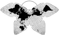
Cahill 1909
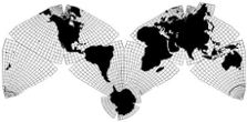
Cahill-Keyes 1975
| Go to complete linklist of Cahill-Keyes map development |
|
|
Cahill 1909
|
Go back to Gene Keyes
home page
Cahill-Keyes 1975 |
Full-text pdf of 1973 MA thesis by Gene Keyes (see new abstract and introduction below) SIX PRINCIPLES FOR A UNIFIED MAP SYSTEM (Applied to the China-Russia Situation) in its original 232-page typescript plus 49 map dummies For Master of Arts at Southern Illinois University, Carbondale Government Department 1973 August ~~~~~~~~~~~~~~~~~ As reprinted 2017-03-15 |
Abstract, 1973-08-10 MA thesis:Six Principles for a Unified Map System
(abstract added to pdf reprint 2017-03-15)
Most world
maps are notoriously distorted and open-ended. Most other
political-historical maps are a chaos of unrelated projections and
perspectives, scales and sizes, grids and graticules, shapes and
formats: orphans with no complete parent world map nor globe.
Regional sections focus on Europe or America; shrink Africa and Asia.
So-called "authoritative" political maps are seldom
available, except as secret weapons of international conflict. Thus,
geopolitical ignorance remains endemic, however well-drawn a
particular map, series, or atlas.
The thesis begins with a critique of political cartography and historical atlases; then elaborates its six principles: 1) Scale; 2) Projection; 3) Shape; 4) Size; 5) Perspective; and 6) Format. The map supplement includes a test sequence using hand, photocopy, and computer-drawn maps (20 cm) to show China and Russia together at 1/50,000,000, from 2000 BC to 1950 AD (19 panels), and zeroes in to Chenpao / Damansky Island at 1/5,000, the site of their almost-nuclear-war in 1969 (20 panels).
*
[at first, Note:
a later version of the
abstract, discussed below in the Introduction to the pdf reprint,
adds four more principles for a potentially revised edition entitled
“Ten Principles for a Coherent World Map System”. |
2017-03-15
Gene Keyes Introduction to the reprint-original of my 1973 MA thesis
As
of now, it has been 44 years since this thesis was drafted. Certain parts
are outdated or superseded, but much remains relevant. Foremost among the
changes I made subsequently is in regard to the "Projection" principle: Less
than two years after completing my ms, I discarded the 1954 Fuller icosahedral
world map, and adapted the 1909 B.J.S. Cahill octahedral instead.
Till then, in the thesis I was striving mightily to make Buckminster Fuller's Dymaxion projection the all purpose base world map for geopolitical affairs, or any other educational intent. At the last minute, I found that the Dymaxion had too many shortcomings. So as a provisional expedient, I depicted my 19 joint historical maps of Russia and China, not on Fuller's, but on an orthographic [sphere-like] projection, marked by me a la Fuller's icosahedral triangles. Yet this was so unsatisfactory that after the thesis had been submitted, I began to realize B.J.S. Cahilll's 1909 octahedral design would have been far better for my purposes. While I had discussed his map in the thesis, its "Butterfly" shape did not seem suitable for the all-encompassing world map I sought; e.g., for horizontal close-ins of any area. Then in March 1975, I reoriented Cahill's octants into an "M" shape: Eureka! Just the map I had been hoping for, with a more-or-less "horizontal" aspect. [Not that there is any "right side up" for a map; but that's another story. Also, I later found out Cahill himself, had depicted an M-layout, but not used it; his whole stock-in-trade was the Butterfly.]
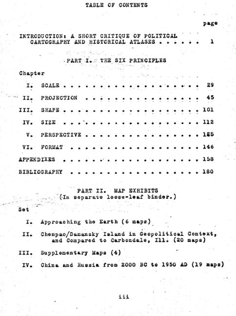
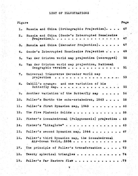
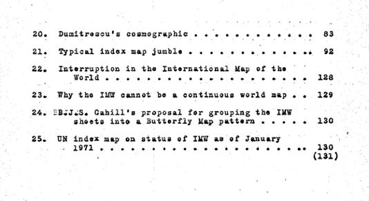
Cahill's cartography had been all but forgotten, and I could not find any off-the-shelf maps of his to work with. So by November 1975, I had devised my own Cahill-Keyes version from scratch, with various tweaks and a brand new graticule. (I also did much research on his originals and variations. Both his design and mine are elaborated in great detail and profusely illustrated on my website, www.genekeyes.com, including an extensive comparison / critique of the Cahill and Fuller maps, and much else.) That is how the thesis is the precursor to the Cahill-Keyes World map, because the C-K accomplishes what I had so vainly tried to make of the Dymaxion: a multi-purpose, multi-scale Megamap, in macro vistas and micro, all from the same Master Map at 1/1,000,000. As well, the Cahill-Keyes is a much better fit in the System itself, dovetailing more precisely with the other principles. Meanwhile, in composing an abstract, which had not accompanied the thesis, I eventually updated it to add four more principles which emerged in the course of my design work on the Cahill-Keyes world map: Geocells; Graticule; Grid; and Global Fidelity, These were all inherent in the thesis, but I decided to elevate them to "principles" in their own right. Briefly, these are the additional ones: 1) Geocells: Is the term I coined in 1983 for an area bounded by one degree of latitude and longitude. All geocells are to be reasonably proportionate to one another throughout the entire map, and all geocells are to be shown in a Cahill-Keyes system map. The principle is amplified in its corollary, graticule: 2) Graticule: I placed great emphasis on the need for world maps and globes to show a one-degree, or at least a five-degree graticule (latitude and longitude net). This principle emphasizes its visibility, symmetry, regularity, and proportionality: criteria altogether lacking in Fuller's map; and conventional world maps; and to a lesser extent, even in Cahill's earlier versions. 3) Grid: The system's nexus is the 1/1,000,000 Megamap, a Master World Profile inscribed precisely in the length of a 40,000 x 20,000 millimeter grid, representing the unrolled 40,000 km circumference of the Earth. [This principle achieved vivid proof-of-concept in 2011, when Mary Jo Graça wrote a Perl program and OpenOffice Draw script for a Cahill-Keyes World Map of that scale and scope in a pdf occupying almost 9.000 square feet (800 square meters), but which can be easily panned, viewed, and re-sized in a Foxit pdf reader: 4) Global Fidelity: is (A) similitude of continents on a [Cahill-Keyes] flat map to those on a globe: a quality blatantly lacking in most other world maps; and (B) a synoptic globe / map partnership, in which the point-for-point pairings of loci on a map and globe are instantly comparable to one another: i.e., octant plus one-degree marked globes exactly corresponding to the octant plus one-degree layout of a Cahill-Keyes map at the same scale. These principles, as well as the original six, have a lot more underlying detail. (See my website.) So for those willing to travel back, back, to the days before the Internet and the personal computer, I now offer my original typewritten 1973 MA thesis via the Internet, as reproduced on my home computers: an OS 9 Mac and a Windows 7 PC, with Foxit Phantom pdf composer, an HP 1210 All-in-One printer-copier-scanner; Netscape 7 html Composer; OpenOffice 4; and ClarisWorks 5. (Even all that hard-and-software of mine is getting long in the tooth; but I digress.) What follows are jpegs of the table of contents, and illustration list, from the thesis. And as mentioned, the entire thesis pdf can be viewed or downloaded from here. Gene Keyes Berwick, Nova Scotia, Canada 2017-03-15 |
|
|
|
|