Recently, over the radio, came this significant
sentence, “The world has now grown so small that the vast oceans
which seemed to isolate us, are now, in effect, no wider than irrigation
ditches”.
There is indeed no spot on sea or land which cannot be covered by
an airplane within a few days, or in a few seconds reached by radio!
This latter miracle is all the more remarkable because it means that
any one man's voice can be heard, literally all over this planet
instantaneously.
To these conquests of the air and ether wrought recently by modern
science, let us add the political conquest of this whole world,
also achieved in the past thirty years, so that there remains not one
single square mile of sea or land which is not allotted or claimed
by one or other of the leading nations of our day. While the
South Polar continent is not yet inhabited, and vast areas of the oceans
but little traversed, the empty continent is already preempted right down
to the South Pole, as one can see in any atlas.
These three outstanding facts make the world of the past 30 years
entirely different from the world of 30 centuries before
aviation
has completed the physical conquest of the Earth, so laboriously pursued
heretofore by exploration, because now any remote and inaccessible
region of ice or tundra, forest or jungle, sand desert or water waste
can be found and photographed from the air.
Radio has
completed the intellectual conquest of the earth because aided by the
cinema, ideas, developed by any one advanced group can be told to
all mankind as though a single school teacher were lecturing in one
super colossal class room, to every man, woman and child on the whole
planet.
Imperialism or colonial expansion, begun at the outset of this
century, by completely covering the world, leaves no unoccupied territory,
so that, for the first time in all recorded history, no one nation can
expand, except at the expense of some other nation!
He must be a dull person who cannot see that these three factors
of the past 30 years have combined to raise a host of problems never
before faced by civilization.
A very brief summary of the long past will
help to realize the miracle of the short present. Civilization began
in isolated regions: the rivers of China; the plains of India and Mesopotamia:
the valley of the Nile. Whence it spread to the Mediterranean
where the Greeks first conceived the world as a sphere according to Eratosthenes,
later divided by Crates of Mathus into four equal parts, one of them
being the “
Oecumene” or home of the human race, a vast region from the
Canary Islands to China, and from the Equator to the Ultima Thule of
Pytheas, somewhere north of the British Isles.
Although Africa had been circumnavigated, this actual quarter of the
sphere was the whole world as known for many centuries, until the
Norsemen and finally Columbus discovered the New World and Magellan
the Portuguese sailed round it in 1520, and so the other three quarters
were finally known. Subsequently Cortes and Pizarro discovered
other isolated civilizations in Mexico and, and so, by slow gradual
progress the world grew larger and larger up to the end of the 19th century.
From that date, however, as we have shown, it has ever grown smaller
and smaller.
Indeed the average man's concept of the Earth begins with the soil
he cultivates near his native village. To this day, farmers
of Yorkshire refer to men of the next village as “furriners”. Small
wonder that men think parochially long before they can think patriotically
as most men think now, and would continue to think everlastingly
but for the fact that, by the three miracles of modern times the world
itself is at long last not only “filled up” actually growing smaller
and smaller so that the final feat of “learning to think planetarily”
will be accomplished easily and naturally.
All the tendencies of our time show conclusively that an international
outlook is as essential to the future of civilization as it was
unnecessary and impossible in the past.
Civilization began in isolation, and grew up in long centuries of
contention. But now that physical and mental isolation is overcome
by science. and political expansion is impossible without war, conciliation
must take the place of contention, and the ideal of world unity must finally
prevail. It is the only way our precious civilization can be preserved.
This coming importance of geography both as an antidote
to the “poison” of history and the best cultural background on which
the coming generation can achieve world order and perpetual peace.
We hear much just now about the “Verdict of History” as applied
to Czechoslovakia. But is the verdict of history, as taught,
either just or conclusive? Napoleon said, “History is a lie agreed
upon”. Henry Ford more bluntly calls it “bunk”. H. G. Wells
does not hesitate to use and even stronger word, “Poison”.
History, in the main, is a record of international conflicts and
the winners tell the story in their own way, which, of course is not
the way the losers would tell it. Whoever heard of history from the viewpoint
of Troy or Carthage?
And, if both sides survive, each gives its own version, so that
in spite of the honest intentions of its authors, history is largely
fictional.
Geography, on the other hand, is wholly factual. Thus while history
teaching is deliberately contrived to feed and perpetuate that “exaggerated
nationalism” so deplored by both Einstein and the Pope as the real
cause of all wars, the study of geography acts as a corrective to
this arrogant patriotism, so that, no matter how big, strong and wealthy
any one nation thinks itself, the rest of the world is far bigger, far
stronger and far wealthier. In other words, history teaching too
often promotes egotism and arrogance, while geography teaching shows
the wisdom of conciliation.
Moreover, the study of Geography begins in all school systems at
a very early age, and as any psychologist knows, early impressions
made on fresh, young minds remain all through life, and in moments
of mass excitement, such as any political crisis, break through all
the superimposed culture of after years and stands out stark and terrible:
the deep down sub-conscious mind of the mob.
So, if in childhood the over-patriotic teaching of history is offset
somewhat at the same age by the more balanced teaching of geography,
whole populations may incline to reason rather than riot. So
far we have spoken of Geography in its simplest form and yet most comprehensive
form as an early awareness of the whole world as soon as we have a
general idea of the extent and importance of our own particular country;
for it is quite impossible to expect any child to master the details
of all other lands as thoroughly as his own. Long before he learns of
other lands through the pages of an atlas, he should know the relative
extent of his country in comparison with all the rest of the world. Once
this ratio between one's home land as compared with the home land of the
whole human race is firmly and pictorially impressed on the mind, other
fundamentals will take care of themselves, particularly those confusing
impressions gathered from a study of the average atlas, where all countries
and continents, however small or however large, are shown on the same sized
page (whether Scotland or China, Italy or Africa, Spain or South America.)
Up to this point, we have considered the New Geography in its simplest
form as a mere outline of ones own land in comparison with all the
rest of the world to be firmly impressed on the mind in extreme youth
as the bed rock foundation of his future culture. After all it is
but the latest of a series of relationships between the individual and
his family, his tribe, his country, his League of Nations whether in
the Old World or New World and finally the whole human race. This expansion
of one's mental outlook does not imply political fusion on international
alliances, but rather the idea of federation
: Christ's Dominion not Caesar's.
The first function of the New Geography, therefore is to accustom
the sub-conscious mind of the next generation to a planetary rather
than the parochial outlook and its intolerant arrogance, which today,
in many lands, so threatens the peace of the world.
So far then, we have used the familiar word Geography to open up
our subject. But this word only covers a very small domain of a much
vaster field for which we require a much more comprehensive term.
In the first decade of this century, the late J. C. Bartholomew, eminent
cartographer of Edinburgh, described the author of the Butterfly Map
as a “geosophical idealist”. So, if the word “Geosophy” is not already
in our larger dictionaries, it ought to be, for we need exactly such
a word to cover the larger applications and implications for modern
world study, which the old word geography entirely fails to suggest,
much less define. The geosophical sciences then, include all
that was meant by geography as well as a much larger group not even
included in the words geometry, geology, geodesy, geodynamics and geophysics,
etc. While this world as a whole has from time immemorial been
the object of astronomical and other sciences, it has only recently attained
its majority so to speak, become fully grown and fully known, or rather,
knowable to the mass of mankind as was shown in the opening chapter.
The geosophical outlook of the next generation will not only include
all the technicalities of science concerning this planet as a whole,
but a radical readjustment of all the social sciences and humanities.
This idea of ultimate world order, is even now the faith of millions
of thoughtful men throughout the world, although, alas, they are still
in a minority. Coming generations, however, educated from
early youth on broader lines will act where this generation only thinks
and the last generation merely dreamed.
In 1913, just before the Great War, William Archer, the translator
of Ibsen’s dramas wrote a little book called
The Great Analysis with a prophetic preface by Gilbert Murray, the well known Greek scholar.
With the imaginative audacity of Jules Verne or H. G. Wells, he supposed,
rather unscientifically, that a small portion of the planet was sheared
off into space with people on it, a pocket planet. This device
was necessary at that time to postulate a world where everybody could
meet and talk to everybody else, because at that time, the author little
dreamed that the miracles of aviation and radio would make the actual conditions
on this huge globe so closely parallel to the conditions assumed on the
tiny planet of his fable. The people thus marooned in space at once,
of course, organize themselves with obvious common sense and quite satisfactory
results. The moral is thus tersely stated in its application to the actual
world:
The human intellect, organizing, order bringing must
enlarge itself so as to embrace in one great conspectus the problems,
not of a parish or of a nation, but of the pendent globe.
But, long before this, Tennyson not only prophesied poison gas bombs
dropping from the sky, but in the same poem foretold the “Parliament
of man, the Federation of the world”.
On September 13, 1913,
The Pacific Methodist Advocate of
San Francisco printed the following:
The new map of the world showing all the land in truth
is not only of educational and scientific use, but it has a higher,
an ethical value. A picture plan of our home, the world, showing
all the nations and their domains as they actually are, so that one
can know the truth about his neighbor, is an advance in cartography along
lines of international conciliation.... World Peace, which is essentially
a Christian ideal, can only grow out of the comity of nations which can
best be promoted and developed by mutual knowledge. Our first knowledge
of the fact that there are other nations than our own we generally get from
geographies and maps. Hence it can readily be seen that this impartial
world map may have after all no small bearing on one of humanity's most
sacred ideals, namely Peace on Earth.
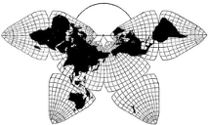
The new map from its odd shape is called The Butterfly
Map. Now the butterfly among all nations has been used as a symbol
of life after death. May not this accidental similitude be interpreted
in the light of a new era for mankind at large too long struggling
in mutual warfare? May it not typify a moral metamorphosis of
the whole planet and the winged awakening of a world conscience whose
flight no man can now imagine?
This it appears that a writer, a poet and a preacher have in various
ways anticipated the inevitable coming of world order and international
conciliation as the only practical road to universal peace, ultimate
disarmament and the final deflection of the billions now spent by
nations to fight each other to the nobler purpose of jointly warring
on ignorance, disease, disaster and crime.
History of the Butterfly Map. Its publication 1909.
The years on probation. Twenty years in completion. Welcomed
in the beginning — Ignored at the end.
In 1904, I came across Andrew Carnegie’s book
Triumphant
Democracy in which the fast growing giant of America was compared
with the tiny British Isles, the latter, of course, were invariably
vanquished. In this book, Carnegie had written “Lord Roseberry’s
absurd attempt to unite the British colonies was doomed to failure”.
I did not agree with this star-spangled Scot and at once set about writing
a counter-blast which I entitled, provisionally “An Exultant Empire”.
While gathering statistics of the combined resources of the British
Dominions, I realized the supreme importance of a world map to show the
whole Empire on one sheet, to a uniform scale and without distortion.
No such map existed anywhere in the world.
And, so, I set about designing one of my own. As an architect,
already interested in geometrical projection, the problem was congenial,
though difficult. However, I had the great advantage of approaching
the subject with an absolutely open mind. Regarding my fitness
for the task I quote a statement by Professor John B. Leighlay, of
the Department of Geography University of California,
The architect is accustomed to the transformation of three-dimensional
bodies into plane figures. This ability to manipulate geometric figures
in space, which becomes second nature to him, may well be envied by any
one who deals with maps. The relatively sterile concepts of the mathematician
in this field are rendered fruitful only by this plastic imagination,
which the architect cultivates to the highest degree.
A map is a plan and in many countries the architect is
also a surveyor. He is familiar with problems of scale and all his
drawings are projections. He is a master of diagram, symmetry and form.
But far more important is his severe training in problems of compromise.
In any great structure there are innumerable conflicting demands,
all seemingly imperative, yet, none of which can be fully met without
sacrificing others. Yet they must all be duly considered, adjusted and
finally welded in a balanced product, the perfect plan.
This is precisely the problem of making a eumorphic world map.
By no miracle can the surface of half, much less the whole of a sphere
be laid out flat in a square, a disc or an ellipse without violent
exaggeration or excessive distortion. Yet a working compromise must
be arrived at by some means or other. But how?
The answer is a simple as it is modern. First of all we must realize
that we are to devise a land map of general portraiture and not
a sea chart of special purpose. And then, to bring the problem within
the easy grasp of everyone, it is only necessary to conceive the continents
as a limited land “pattern” on the much larger water surface of the
globe which must be symmetrically cut out so that it may be uniformly
laid flat. Or, conversely, we must design an orderly world pattern
on a piece of fabric, the containing seas, so outlined that it can
be fitted around a sphere or pseudo-spherical solid.
If the reader does not quite get the idea of a “pattern”, let him
examine the car in his garage, the clothes in his closet or the cartons
in his kitchen all build up from flat patterns stamped out of steel
or cut out of cloth or cardboard. Strange and unfamiliar forms
when flat but quite ordinary and familiar when bent, stitched or folded
into form.
From this, it is at once quite clear that no rectangular,
circular or elliptical piece of cloth can be fitted around any curved
surface, except in the case of a rubber model, and therefore it becomes
necessary to first flatten the globe of derivation into some form
of regular solid before the world map can be fitted around it.
An octahedron or eight sided figure alone of all the five regular solids
or Platonic bodies serves this end. This conclusion was arrived at by
a long circuitous route after many experiments with the gores stripped
from a globe, far too tedious to describe in detail.
Suffice it to say that it required several years to work out the
first sketch map on which the whole British Empire could be shown
without noticeable exaggeration or distortion. But by that time,
the original secondary purpose of the Map had been forgotten. The great
fire of San Francisco in 1906 had destroyed all my manuscripts and nothing
remained of permanent value but the Map. This was described in an
illustrated paper in Edinburgh 1909.
It was at once welcomed with an astonishing unanimity of praise.
An expert critic writing in the November number of the
Scottish
Geographical Magazine, said that no conceivable method of projection
could give “at once such a comprehensive and accurate representation
of the globe as the map which is here shown. Its form is almost
self-explanatory of the method of its construction, which is so simple
that the merest child can easily understand it”. The astronomer Waldemar
Kaempffert, then editing the
Scientific American and now the
Science editor of
The New York Times called it “The best attempt,
so far, to map the globe in a plane”.
Alfred Russel Wallace, the co-discoverer of Evolution
with Charles Darwin, found the map “more accurate than any other
yet attempted”. The versatile Ernst Haeckel, foremost of German
scientists, was the first to point out a feature of the Butterfly
Map which is invariably overlooked by others. He wrote, “The
new and original projection shows the true relations of the continents
much better than in the different older attempts of cartographers."
It is a notorious fact that experts in any subject are usually blind
to any revolutionary idea in their own field. Their heads are so
crammed with textbook teaching along traditional lines that any brand
new idea almost invariably escapes their notice. It was the experts
in steam engines who turned down the gas engine.
There were notable exceptions, however, and among them must be
mentioned Max Groll of the University of Berlin, Col. Sir Sidney Burrard,
Surveyor General of India, Emmanuel de Martonne, geographer of the
University of Paris, Geo. W. Littlehales of the Hydrographic Department,
Washington D.C., Dr. Cleveland Abbé, Chief of our Weather Service,
as well as W. M. Davis, the well known geologist of Harvard University.
To this short list could be added dozens of other exponents of the
geosophical sciences, who welcomed the new Map with more or less enthusiasm.
On the whole, the map was acclaimed wherever it was known, so much
so that the only three exceptions assumed more importance in the author’s
mind for this very reason.
It has always been my contention that the objectors
to any new idea are of more value than the supporters, because
it is from their criticisms that the corrections, improvements and
refinements, so essential to any invention’s permanence, can be finally
worked out before the product can be pronounced perfect.
Most inventors of a brand new and original world map would have
been spoiled by this overwhelming acclaim. And, for a few years
I will admit that I thought the map in its first form was sufficiently
complete to justify its commercialization and worked for several years
to that end. This first map whose all-round qualities, in spite of its
scientific shortcomings, made it useful as actually the best map of
the world to date, had a marked success.
Even now that it has been developed into a complete scientific System,
that first version will still serve and probably turn out to be the
most used of all the subsequent Variants. It was actually employed by
the War Department to illustrate a flying trip around the world. Indeed
aviation was its earliest application as witness
its use to exploit the
first Circumaviation ever proposed for the Panama Pacific Exposition
in San Francisco 1915, where by the way it was exhibited and won a gold
medal. It was then used by the State of California to illustrate
shipping routes for a Harbor Commissioner’s folder and afterwards similarly
employed by the City of Charleston. In 1924, it was employed by the American
Express Co. to illustrate the S. S. Laconia’s world Tour. Among the passengers
was Robert Ripley, who saw the map daily as it was displayed on the Palm
deck. He afterwards recalled this and illustrated the map very
effectively as a feature of his “Believe it or Not” series.
And while on the subject of publicity, the map was illustrated,
printed and written up to a truly astonishing extent by the magazine
publications and news agencies throughout every State in the Union,
as well as in Canada and the British Isles. It is a safe estimate
to assume that the map in its first form was seen by at least thirty
million people as attested by two bulging scrap books of clippings.
Indeed, the publicity was so effective that a
prominent New York firm of map publishers wrote to me for the exclusive
rights to print and sell the Butterfly Map.
[Hammond. —GK]
In order to help defray the heavy expense of map draftsmanship and
publicity engineering, I had formed a corporation to commercialize
the map, which all my friends assured me might be very profitable.
The original idea was to make and print our own maps, but when this
firm undertook to relieve us of this responsibility, we agreed to turn
the whole enterprise over to competent experienced professionals. And
so we closed a contract to that effect. At this time I thought
that our troubles were over. The map was completed academically, most
effectively advertised without spending a solitary cent, and finally
adopted by one of the country’s outstanding publishers. What more could
one wish for?
But we were mistaken on all three counts. The map was
not perfected
academically, we had
not achieved anything like enough
publicity and to cap the climax the very firm who had importuned
me to give them an exclusive contract failed, after a year, to live
up to it.
The inside truth, as I subsequently learned, was not the unpopularity
of the map, but the failure of a sub-contractor to live up to his
agreement with the publisher, whereby he had agreed to take enough
maps to pay the publisher for his contract with us.
This seemed the end of the Butterfly Map: its death and burial.
Few of life’s disappointments have ever so completely depressed
me. Luckily, a great increase in my professional work, helped to drown
my sorrow. So, for a year or two, I tried to forget the map by once
more becoming absorbed in my regular work.
But, as so often happens in life, what seemed to be a calamity turned
out to be a blessing. In spite of the apparent failure of the map,
I could not fail to realize that I had the right idea for a permanent
world map, so why not make assurance doubly sure, go over the whole
project from the beginning and lay the foundations so firmly and so thoroughly
that no possible critic anywhere in the world either now or at any time
hereafter could raise a single valid objection to this map, no matter what
test it was ever put to. Already I had come to realize the great importance
of this undertaking. If it was to endure through the ages, nothing else
but absolute perfection should be my goal, no matter what time, what trouble,
what expense it involved.
How I finally determined to begin all over again and so develop
the Octahedral System out of my first provisional Sketch Map, as
I came to call it, is described in the following chapter.
The second phase of the Butterfly Map — The three Variants
and sub-types — New publicity and final geodesic endorsements.
In the last chapter, I stated that there were three notable objectors
to the Map as it was first presented. They assume so much importance
that I shall name them and define their adverse criticism. The first
was R. S. Woodward, then President of the Carnegie Institution of
Washington. He wrote me to the effect that (a) there were any number
of projections, (b) that these were the work of the world’s most eminent
mathematicians, and (c) with a touch of sarcasm, “Who the deuce was I
anyway?” Not his actual words but his exact meaning.
The second critic was F. C. Hayford, of Isostasy fame, who patronizingly
informed me that I did not know the first thing about the requirements
of map draftsmen, but that my amateurish efforts, however praiseworthy,
would never be taken seriously.
The third critic was A. R. Hinks of the Royal Geographical Society
of London who briefly described my work in the Journal somewhat jeeringly
and with little sympathy. Subsequently we had a copious correspondence
through many years ending in his reluctant conversion. But that
is another story.
I have already mentioned some of the experts who praised my map
but a very large number of my champions were merely men of general
culture, writers, etc. Among these was the late Ambrose Bierce.
What he wrote me from Washington is characteristic enough to repeat.
I had told him of my severest critics and this is what he wrote,
“The Butterfly Map is indubitably the right one, but it will be a
long time before it gets into general use and then it will be known
as the Hinks-Hayford projection or I am no true cynic”.
In resolving to begin all over again I realized that nearly all
geodesist critics, however friendly, expected me sooner or later
to show some “mathematical foundation” for my work. So to the
task of supplying this and working out in full all the Variants, their
sub-types explanatory diagrams, theory and computed tables I devoted
about twenty years more time after the ten years had elapsed since the
map was first described in 1909: a period of 30 years. Add to this the
several years in the first development of the design and we have a grand
total of about 35 years which to the average man seems an incredible amount
of time to devote to one project. However a well known writer for the
San Francisco Chronicle, Mr. Chester Rowell, after a rather
thorough study of the development of revolutionary inventions has come
to the conclusion that on an average, they require about 35 years before
any one of them is completely established.
Nor must it be supposed that progress proceeds in a direct line.
No new trails along any direction of progress are blazed in any such
simple manner. Instead, there are many digressions in the wrong
direction, much retracing of steps, many false starts. It is only when,
after many hardships trials and disasters even, that the real road is
found. And then, of course, looking back over the completed highway,
all seems simple and direct.
Nor can one place too much value on the negative act of waiting.
The mere lapse of time works wonders. After the passage of months
even years an unfinished problem looks very different when one returns
to it, very different from what it appeared when one left off working
on it.
Moreover, the ability to look at any difficult problem from every
possible angle largely depends on changing one's point of view not
only in space but in time.
Quite probably no one in all the world has spent so much time and
thought on this one problem. Now that my task is done in such a thorough
a fashion that it cannot be improved upon I feel that I have earned
the right to speak on the subject with authority. At this point
it may be asked by some one, “
How do you know that your work cannot
be improved upon?” For some time I was rather puzzled how exactly
such a question should be answered. The statement that I have
tried out every method does not quite suffice. Nor does the demand
for a better example quite satisfy. But lately I have discovered
a way of answering this question which will convince even the most exacting
of critics.
There are some few inventions which so perfectly fulfill their purpose
that they are final or to use the right word
unique. No other device whatever will serve. Luckily the very best example
I can suggest lies also in the field of projection.
I refer to Mercator’s chart. It was designed for one and only one
purpose: to serve wind driven ships with nothing to guide them but
the mariner’s compass. The skipper simply laid his ruler on the chart
connecting Bristol with Barbados and the angle this line made with the meridians
gave him the one compass direction to follow. No other diagram will straighten
this line which is a
curve on the globe. In other words, Mercator’s
chart is for sea sailing exclusively whose only attribute is the one
not found on a globe. The Butterfly Map is for land purposes
mainly and combines all the eight attributes found on a globe whereas
all other world maps represent but
one attribute of a globe. No
other form of world Map except that of the octahedral Butterfly can possibly
represent all eight. The Butterfly Map is a sort of reciprocal of Mercator
and both are sui generis or unique but the former is of far more ancient
lineage as we shall see later on.
Regarding the mathematical computations, more than two of the exponents
of this science have shown unusual interest in the Map: Florian Cajori
of University of California, compiler of an Encyclopaedia or History
of Mathematics and translator of Newton’s Principia as well as Cassius
J. Keyser, the author of “Mathematical Philosophy”. It is the latter
who said of the Butterfly Map in its earliest stage, “Only a stupid world
can long refuse to use it”. But while these two are widely and
favorably known, neither of them has specialized in the subject of Map
Projection so successfully as Dr. Oscar S. Adams, Senior mathematician
of the Coast and Geodetic Survey and well known to all the specialists
in this field.
It is the custom of architects to employ and pay for the services
of specialists in the matter of steel construction, air conditioning,
etc. and no better man could be retained for map computations anywhere
in the world and I was indeed fortunate to secure his services.
The architect as a creative designer uses the synthetic and intuitive
methods beginning with the general and working towards the particular.
A mathematician employs the analytical method working from the particular
details out towards what is general and comprehensive. He advances
by infinitesimals. Anything like intuition is anathema
in his creed. And this is undoubtedly the only correct method for
local regional or national areas, or whole continents providing they
do not spread over more than one eighth of the earth’s surface.
But when, on occasion, mathematicians and geodesists try their hand
at a world map by beginning with detail, they can only end in disaster.
Any draftsman who, with a hard pencil begins to design a house by drawing
in the entrance and then adding the rooms exactly as they should be and
expect to finish his plan satisfactorily, is foredoomed to failure.
In fact A. R. Hinks of the R. G. S. in his book on map projection states
specifically that “the problem of mapping the whole world on a single
sheet is intractable”. And this exact sentence is repeated verbatim
in a far more pretentious volume on map projection written and compiled
by Deetz and Adams.
Of course this is only true when the designer fails to decentralize
and expects to succeed by working from one point, arc or line, and
so expanding to cover the whole globe.
In other words, the statement that it is “intractable” or impossible
to map the whole world on one sheet, that is, of course, with a reasonable
degree of accuracy, should be amended to read, “intractable by the
methods used in mapping limited areas of national dimensions or at
most the scope of a continent”.
All this means that the legitimate field of the mathematician
should be confined to regional mapping for general purposes and only
extended to cover larger regions or the whole world for
special
purposes such as Mercator’s chart for reducing the curved compass
course on a globe to a straight line on the chart, or a gnomonic map
chart to express all great circle courses in straight lines, etc.
When the mathematician extends his mapping as distinguished from
charting to cover the whole world, the result will always be freakish
in its exaggerations or distortions however flawless in its mathematics.
Now it is a well known fact that professional mathematicians have
much in common with virtuosos in music. They like to exercise their
technical accomplishments and, being human to “show them off”.
Many of them in their spare moments like to “take a postman’s holiday”
and beguile themselves with problems of projection not permitted in
their working hours. So long as these excursions into the fascinating
fields of analytical geometry are regarded merely as avocations and
as such are even published in some of the numerous magazines devoted
to ideal mathematics, well and good. But great harm comes when these “geometric
trifles” are published as serious contributions in the service of geography.
As far back as 1912, Mr. Hinks began his book with this sentence,
“The subject of map projection has become overcomplicated by too
many mathematicians”. But far from checking this tendency it has grown
since that date to amazing and extremely mischievous proportions.
At no time since the dawn of civilization have we ever so needed
a rational standard world mapping system yet at no time have we been
so misled and bewildered by the very men who should help but have only
hindered.
In the present age, the science of mathematics is, perhaps rightly
the greatest of all. In fact it occupies the position in the public
mind that theology did in the Middle Ages. Its practitioners command
supreme respect so much so that any dissent or appearance of dissent
from their dogmas will not be tolerated. The priestlings of projection
take advantage of this knowing that they will be listened to and their
critics will not.
In proof of this let me cite examples of this intolerance. The dean
of English projectionists is probably Sir Charles Close who contributed
an article on this subject to the Encyclopaedia Britannica.
He wrote to me quite dogmatically that “an architect could not
judge the merits of a world map as well as a geodesist”: as though
only a cook could tell a good entrée. This arrogant attitude
is the first prejudice to overcome in the minds of those who only respect
an expert’s opinions. The Frenchman M. Louis Driéncourt, joint
author of a truly monumental treatise on projection, informed me in one
of his letters from Noyen that “there could be an infinity or infinities
of world maps and that no one could flatter himself that his own was
the best.”
This amazingly ridiculous statement is clearly meant to perpetuate
forever the amusing sport of excogitating world maps, coupled with
the pontifical announcement that a final adequate standard map of
the world is not only impossible but not even to be aimed at: something
sacrilegious and anathema; something like “killing the fox” in an
English hunting field. The statement is obviously rather a wish
than a prophecy.
Just before the Spanish war, Karl Heinz Wagner sent me from Barcelona
his autographed book
Unechten-Zylinderprojectionen
published by the Deutches-Seewart of Hamburg, a very expensive and
elaborate collection of strips of world mapping in several directions
based on the various elliptical world maps first devised by Mollweide.
Not one of these strips or bands can be extended to cover the whole
earth without hopeless distortion. Each, moreover requires separate
computations separate draughting and separate printing! In reviewing
this book in the R. S. S’s Journal Sir Charles Close almost glowed
with interest in the daring device of an oblique maps as though they
were daring novelties.
In strange contrast to all this clumsy roundabout utterly impracticable
group of separate maps, is the simple quite inexpensive methods of
the Butterfly System which, by merely changing the octants in
the printers’ forms can show the continental masses in from six to twelve
directions oblique as well as cardinal, all on one projection and each
including the whole world. Is it to be surprised that I told Karl Heinz
Wagner that his whole book represented an utter waste of time and money,
the very thing I have spent nearly forty years to obviate. Yet, from the
very beginning my attitude towards mathematicians has been persistently
mis-represented. I have stated clearly that algebraic detail should be
subordinated to Design and not the reverse.
In a recent comment on my Gnomonic Variant in
Petermanns Mitteilungen
Herr Eckert-Grieffendorf, a prolific writer on map projection returns
to the charge in a rather ponderous explanation that in the end I
had to employ mathematical methods, quite forgetting that if I had
employed them
in the beginning I could never possibly have designed
an adequate world map. Such a feat has been officially declared
“
intractable” on both sides of the Atlantic: while all world maps
designed by this method have been definitely described by the experts
of the Coast and Geodetic Survey as “mere geometric trifles”.
In the earlier years of map projection the method of computing net
intersections, the crossing of parallels and meridians, was merely
a convenient device for enabling the map draftsman to trace continuous
lines through these points measured off coordinates. But as the
science of projection became more complicated and the differential
geometry of surfaces was developed by Gauss and applied to mapping by
Lambert, this scaffolding, as it were, became even more important than
the building, in other words, the theory or mathematics became the real
objective and the map, a mere by-product. The niceties of the operation
were of more concern than the “life or the patient”.Like the famous recipe
of Brillat Savarin, so perfect, so lengthy and so elaborate that the resulting
“dish” was fit only “to be thrown out of the window”.
One important result of this tendency to magnify the importance
of the mathematics quite regardless of the map itself and its value
to geographers was the final divorce of theory and practice so that
map projectionists went one way and map publishers another. Their respective
roads diverged so completely that they are no longer in sight of each
other even. As I shall show in a succeeding chapter the men who design
and compute world maps have no influence whatever on the men who publish
world maps and the publishers in turn pay not the slightest attention to
the theorists.
The result of this complete separation of theory and practice is
that innumerable but quite useless world maps are accumulating in
the archives of learned societies, at the same time that a limited few,
but equally worthless world maps are being printed and sold to an
ignorant and indifferent public just at the time when a really adequate
world mapping system is most needed.
In the history of useful inventions it is a commonplace to note
that when a real revolution is necessary, that revolution will most
surely arrive.
In the next chapter we shall see just what is required in a perfect
world map and at the same time what is offered.
The eight attributes required in an ideal world map and
the unbelievable inferiority of the world maps now on the market.
Probably the best book on map rojection in the English language
is the handbook by Deetz and Adams published by the U.S. Coast and
Geodetic Survey in Washington D.C. from which I have already quoted.
Naturally not very much is said about world maps, after admitting
that the problem of designing one by the usual methods of the Department
is “intractable” and that most of the off-time attempts to do the impossible
are only to be regarded as “geometric trifles”.
However, one memorable sentence of this book should be written in
letters of gold. It states an obvious fact which seems superfluous
yet as many philosophers have found, a truth may be so obvious that
it is seldom seen. And like an oracle of old the author of this
lyrical line has unconsciously lapsed into verse — "
When map and
globe do not agree, the former is at fault."
The Butterfly Map is wholly designed to comply with the teaching of this
text. Indeed it is the only world map which "agrees with the globe" as
we shall now see in logical detail.
The attributes or qualities of a globe which can be reproduced on a map
are eight in number, four of them geometrical features of the globe considered
as a surface and four of them mechanical features of a globe considered
as a solid.
The first four are as follows:
(1)
SCALE, that is to say all distances from any one point to any other on the map should be approximately correct, that
is in as close agreement with the same distances on a globe as measured
by a flexible but unstretchable tape. If exact distances are required,
they may be secured on the Gnomonic Variant and in no other way.
(2)
FORM or shape of outlines which is secured by right
angled crossings of the parallels and meridians without, however
stretching, that is enlargement of the scale. This attribute like SCALE
is of two kinds: geographical form without scale enlargement, and mathematical
FORM known as Conformality or Orthomorphism which can only be attained by
stretching the scale uniformly from the center, radially to the edges
of each Octant.
(3)
AREA of the globe like SCALE and FORM can also be
attained in two ways: correct area of each Octant as a whole, (and therefore
the map as whole) with certain defined subdivisions of the Octants all
as shown on the ORTHOMETRIC Variant. This word has been coined from the
Greek meaning "correct regions" to distinguish it from a truly EQUAL
AREA map, the second way by which each "square" or small rectangles
of the net are called. After much study of this alternative,
the author has come to the decision that correct areas by regions is very
much to be preferred to correct area by "squares" for the simple reason
that mathematical exactitude in this particular is of secondary importance
because no computations are ever made on an equal area map.
Its appeal is wholly to the naked eye. Secondly equal area maps that are
meticulously mathematical involve intolerable distortions, especially at
the Poles. Of the two evils, final choice is made of the lesser.
(4)
DIRECTION so that any direct line between any two
points on a globe are also straight lines on the map, or parts of a great
circle. This quality can only be secured on a gnomonic map. In the
special case where this map, or group of separate Octants are enlarged
to Tetrant charts, is described in a subsequent chapter on construction.
The four mechanical attributes of a globe which must be somehow represented
on the Map are as follows:
5)
REPLACEMENT by which the Map brings any Octant in
any required position as when we revolve a globe to bring any part of it
under the eye.
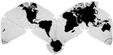
Since the Butterfly Map claims to "suit all nations", it is obvious
that for American use the United States should be in the center of the
Map showing Atlantic and Pacific on either side, with Europe and Africa
on the right or East, with China and the Australasian group on the left
or West. But if the Map is used in Europe, the Atlantic should be placed
in the center. When Russians print the Map the Indian Ocean would be on
the central axis. For Japanese use the Western Pacific should be central.
These different presentations do not need separate projections, but merely
a replacement of the separate Octants in the printers forms, an infinitely
simpler thing.
But supposing the people of Australia and New Zealand want to show
their mutual relationship as well as their position in respect to Old and
New world. In that case the Butterfly formation must be changed as in the
illustration (###). This and three other similar replacements, have the
advantage of a verticality
[horizontality? —
GK] of place
names not possible on the Butterfly formations.
(6)
CONTINUITY, as also when we revolve a globe in various
directions is a valuable feature or attribute especially since the advent
of aviation. Since the main boundaries of all Octants are straight lines
this continuity can be secured in six, ten or twelve different directions,
both oblique and cardinal from each Octant. This attribute has been so completely
overlooked by cartographers that not a single world map now in use is
capable of continuity in any direction whatever! On Mercator's chart (remember
it is not a map) this valuable quality is preserved in two directions,
due East and due West, which, however are of far less practical value than
continuity in oblique directions.
(7)
PLICATION, which perhaps is an awkward word, but
then so is FOLDABILITY. However, it expresses the peculiar quality of bringing
every exposed edge of the Butterfly Map into correct contact, by folding,
with other exposed edges thus expressing on a plane the fact that the
globe is a "continuum" or that all parts are connected with all other
parts. For instance, if the map is cut around all edges, one has only to
fold all four Southern Octants under at the Equatorial line and turn the
map over to bring the Southern Hemisphere into lateral continuity exactly
like the Northern Hemisphere on the normal Butterfly Map. But there are
still two exposed edges. One more fold on each side brings these too into
contact. A final fold brings all eight Octants to the size of one. This
may be slipped into a heart-shaped case as a complete pocket Atlas and
map of the world. One side may be physical, the obverse political. If to
a large scale, the eight part Atlas can be used for desk study in part
or hung on the wall, in full.
Unlike the usual rectangular Atlas every sheet would show exactly
the same area, and each Octant would be to the same scale, in strong contrast
to the bewildering atlases now in use.
(8)
SOLID MODELS, either as a hollow rubber ball, which
can be cut open and laid flat in a photographer's printing frame or as
globe-like polyhedrons of eight or fourteen sides over which the Butterfly
Map can be folded with perfect fit, the very nearest thing to a globe but
with slightly flattened surfaces, proving practically that Map and Globe
are one, or as nearly one as human ingenuity can make them.
The utter inadequacy of the world maps now published,
for sale and in actual use in the world's schools, colleges and universities.
The world maps now in common use in schools and for commercial purposes
generally are of two kinds followed since the early years of this century
by their derivatives which are of three kinds, five in all.
(1)
Mercator's chart comes first. It was never meant for a world map
but designed and dedicated "ad usum navigantium" for the use of mariners.
But since it was extensively used it gradually got into circulation as
a world map and as such has remained ever since 1559 when it was first printed.
Since the invention of steam its original use is largely obsolete, but it
has very many points in its favor when its principles are understood. One
of its advantages, seldom if ever pointed out is that as the scale increases
towards the North, it yields much more room for place names as we ascend
from tropical lands to the more populated and more civilized regions of
Europe, Asia and North America. Otherwise these exaggerations, are so misleading
that the chart should never be seen in the school room. Moreover this chart
is quite useless for many modern problems. It exhibits only one of the enumerated
attributes of a globe, as we have seen, continuity in two cardinal directions.
(2)
Mollweide's Equivalent world map was published in 1805 as a corrective
to the exaggerations of Mercator but its distortions were even worse. As
Hinks says: "It can scarcely be called a map". It exhibits only one of
the attributes of a globe, viz, Equivalence. None the less this map has
been very extensively used, because its more central portions are of excellent
portraiture, and if the nation using the map is in a favourable position
who cared in those days how far-off nations had their land twisted. But as
the 19th century drew to a close and Imperialism spread all over the globe,
far-off places of the earth became of more and more importance and dissatisfaction
in both these forms of world maps became evident so that many experimental
essays in projection by theorists who had little regard for either the general
public or the Map publishers.
(3)
Van der Grinten about 1908 contrived a world map which was described
at the time as "a lucky strike" and has since been defined as "a simplified
Mercator. In truth it is something of a cross between the square map of
Mercator and the ellipse of Molleride, being circular in outline with the
good points of neither parent and the bad points of both. Just how the straight
lines or Mercator's can be "simplified" by curving them is difficult to
explain. This map has the virtue of "looking all right" to the eye accustomed
to a compact rather than an articulated map or the world. If ever there was
a mongrel map or pinchbeck projection this is it. It alone of all the world
maps now in use has not a single one of the eight attributes of a globe.
About the same time the Butterfly Map appeared, which has all eight
attributes of a globe. This had been submitted to Prof. John Paul Goode
Geographer of Chicago University. He was enthusiastic about it and led
me to believe that he would publish it in an atlas he was editing for Rand
McNally & Co. He was much impressed with the general publicity my work
was acquiring especially in a long illustrated article in
The Literary
Digest then at the peak of its circulation. More than all he was stirred
by the "ingenious exposition of the misleading features of Mercator's chart
and its bad influence in our public schools". But as the years rolled by
he ceased to talk about publishing the Butterfly Map because in the interim
he had commenced work on a world map of his own. This map of the world designed
by
:
(4)
J. P. Goode was an "interrupted" version of Mollweide's Equivalent
ellipse. In reality it was a DISrupted Map so split up above and below
a horizontal Equator that it gave an impression of slip-shod disorder where
one looked at least for symmetry if not elegance. In fact, it was downright
ugly. Now an instinct for beauty is far more common than the craving for
truth and although the map was published with all the weight behind it of
the great firm of Rand McNally & Co., it was never popular and never
a complete success.
Some years after its first appearance I learned from a school teacher
who was present at a lecture by Dr. Goode who told his audience that he
was inspired to design this world map by my own efforts in that direction.
I recall writing to him to the effect that "'he should make brag while
the sun was shining, that, for the present it was his innings my turn
would come later." He had everything in his favour, his University gave
him prestige, the Rockefeller millions provided the money, The Coast Survey
printed his projection and Rand McNally put his map on the market. To prove,
however that Goode was in an unholy hurry to make good on his map is born
out by its slovenly construction easily improved upon by Samuel Whittemore
Boggs who reproduced the same map but laid out on more scientific lines.
Col Craster did much the same thing for English use, but most extraordinary
of all was the work of
:
(5) [Douglas?]
Johnson the cartographer of Rand McNally who, realizing that the
buying public objected to the gaps above and below the map proper filled
them in with blue paint, omitting the meridians which might give away the
trick but enormously falsifying the oceanic areas. This is, of course a
cartographic felony, but everything is fair in love, war and business. I
am told that this map is selling like hot cakes.
The last two maps mentioned are all derived from Mollweide's ellipse
and have each only one of the eight attributes of a globe, Equivalence.
The Dutch naturalist De Vries in writing on mutations observes that
many plants have a short period when "sports" or variations are to be
looked for, followed by longer intervals of stability. Much the same seems
to happen throughout all nature. It may even happen in commercial products.
When the Butterfly Map first was described the map publishing world was
in a state of instability. Then followed the venture into new types of projection
as described above, followed in turn by a period of conservatism to use
a rather flattering word for if the truth were bluntly told it is the final
sleep or stupor which precedes decay and death.
No world map now published can possibly meet the demands of modern
times, consequently they will fall into desuetude once a really adequate
world mapping system becomes known and available. And then will come the
real revolution in geography where a hundred competent world maps will be
used where now but one make-shift map is seen, because once the publishers
are convinced of the greater value and far greater demand for the new map
they will soon forget the old ones and scrap the plates. Meantime they cannot
be blamed for pushing the sales of the old ones and even resisting all exploitation
of anything better This "resistance" may be effective for a brief transition
period until from an unsuspected quarter an overwhelming publicity will
place the Butterfly Map System in sudden universal demand and then the dawn
will break as quickly as sunrise in the Tropics!
A brief recapitulation of the whole story will place the picture clearly
in the reader's mind because it is a large and complicated theme along
unfamiliar lines and not easily grasped by experts, much less the average
layman. Moreover it must never be forgotten that the new map was not designed
for the few, the highbrows, but for the many, the lowbrows; not for the
professors but for the public.
Heretofore, indeed, this has been the trouble. The subject of mapping
the whole world has of late years (since the beginning of the century)
become diverted in two directions, up in the clouds and down in the mud.
The mathematicians have lifted it high above the comprehension of the common
man while the publishers have degraded it to the level of a catchpenny commercialism.
The role of the new map is to bring theory down to earth in the service
of common sense and at the same time to elevate commercialism to the dignity
of science.
In the field of regional or national cartography this has long ago
been accomplished. In many instances the map publishers of the world have
been also the publishers of geographical progress, especially in Europe.
The firm of Justus Perthes in Gotha not only makes maps but publishes
Dr.
Petermann's Mitteilungen Geographischen, probably the foremost magazine
of its kind in the world. The firm that was J.W. Bartholomew & Sons
who print the best looking maps in the English speaking world are also the
publishers of the
Scottish Geographical Magazine. Edward Stanford,
famous map makers of London, are also the printers of the
Journal of
the Royal Geographical Society, while Geo Philip & Son get out
Geography,
a magazine of Manchester, England. In this country the firm of A.J. Nystrom
are also the publishers of a geographical magazine in Mankato, Minnesota
and so on...
Since the science of projection as applied to regional or national
maps is neither new nor particularly controversial, there is no conflict
between theory and practice. They march hand in hand.
But the science of world mapping, apart from charts of special purpose
is, as we have seen, an entirely different field, little explored, because
little needed in the past, and now in its infancy (although destined to
attain its majority very soon) and, as a consequence in a state of controversy,
darkness and doubt. But recent developments of imperialism, aviation and
radio have lifted the subject into the spotlight of world-wide interest.
Although not yet realized by the vast majority of mankind it will soon
be and that with the amazing rapidity in which new ideas, no matter how
long in preparation, are wont to spread over the earth, especially when
the world actually needs them.
It was a full realization of all this that convinced the author of
the Butterfly Map to lay the foundations of his structure both deep and
strong so that the final structure would be imposing, convincing, and above
all things
enduring.
While all the technical details of this monumental edifice have been
scrupulously attended to throughout a period of nearly forty years with
almost unbelievable zeal the author has also realized that the value of
his product would be enormously enhanced if, besides its technical perfection,
it should also make its appeal to more than the latent love of truth and
beauty inherent in human nature and that third appeal is to the innate reverence
for precedent and the inner conviction that a revolutionary idea is yet founded
in antiquity and rooted in the past. Solomon the wisest of men has told
us that "there is nothing new under the sun" and if a new idea can also
be shown to possess the sanctity of antiquity nothing further is needed
to its final acceptance.
Therefore in the next chapter I shall show that the Octahedral System
of dividing the globe is as old as civilization and what is still more
astonishing, has persisted right down to our own times, a fact never before
suspected much less proved by incontrovertible evidence. While the first
evidence of this extraordinary story was discovered a year after the publication
of the Butterfly Map in 1909, the details were not fully realized until
thirty years after.
The ancient lineage of the Octahedral System and the proof
from history that regional or national cartography is an entirely different
subject from World Mapping and that the two have descended from antiquity
along different distinct lines.
From the very first the author of the Butterfly Map has realized that
the science of regional or national mapping was an entirely distinct science
from the art of world mapping and not to be solved by the same methods.
When geodesists have attempted to map the whole world they have failed by
their own confession and produced nothing but "geometric trifles". On the
other hand when geographic amateurs have tried their hands at world mapping
they have failed also. Something was lacking on both sides. The theorists
were deficient in practical sense, the practical men were deficient in theory.
The only solution possible was when a practical man took command by making
first a comprehensive decentralized Design and then called in the theorist
to compute the mathematical details. But the captain of the enterprise must
also be fully conversant with the general principles of the theorist because
it was precisely this deficiency which spelled failure in all the recent
abortive attempts of too commercially minded amateurs mentioned in the preceding
chapter.
I cannot repeat too often or too emphatically that the two branches
of cartography are distinct and different and both requiring a distinct
and different approach and for final and complete success the latter must
be in full control and yet in full sympathy with the former. Philosophically
speaking the first is the mental concept of the "many" or plurality, the
second the concept of the "one" or unity. This is the metaphysical idea.
In theocracy we have the Greek as contrasted with the Hebrew. In military
matters we have tactics throughout the field and strategy at C.H.Q, In medicine
we have the specialist and the general practitioner and so on indefinitely.
But it is to be noted that the latter should control the former.
In cartography we have many national maps but one world map.
The notion that there must be
many regional maps and
one world map (even if we have a trinity of Variants) is as old as civilized
history.
The Greek astronomer Eratosthenes demonstrated that the world was
a sphere. He even calculated its dimensions with surprising accuracy.
About two centuries later (200 B.C.) Crates of Mallus in Cilicia, a grammarian
and school teacher devised what has been called the Orb of Dominion by
which he divided the globe into four equal parts exactly as the Butterfly
map is divided if one central great circle line dividing Europe from Asia
is omitted. These four parts he named: One of them, from the Canaries to
China he called the "oecumene" the home of the human race. Vertically it
extended from the Equator to the Pole. The opposite quarter he called "The
Antipodes" clearly showing that its imaginary inhabitants walked upside-down.
When Ptolomey of Alexandria published his first atlas, based in previous
maps of Marinus of Tyre, he showed this quarter of the globe as all that
was then known of the world. From this atlas, which persisted all through
the Middle ages are derived all regional and national maps and atlases ever
since down to and including the finished and elaborate products of our geodetic
and ordnance surveys of today. This covers historically the long and immense
line of the
many maps of the first group.
Now let us follow the very curious history of the four part globe
of Crates known as the "Orb of Dominion". Since only one quarter of the
actual world was known in ancient days, it is unlikely that geographical
globes were made in detail, but we know that this Orb of Dominion was used
as a symbol of earthly sovereignty by the Romans who surmounted it with
an eagle fastened it to a banner staff and carried it at the head of their
conquering legions. Later on the early Christians used it but surmounted
by a cross and often seen in the hands of the infant Christ and so pictured
in the crude mosaics of the catacombs. It was also painted on triptichs,
and altar pieces, stained glass windows frescoes and canvasses all through
the centuries down to the present day. In smaller form it was placed on
the end of a short rod or scepter as one of the insignia of royalty and used
in the coronation of Christian monarchs right down to the late ceremony
in Westminster Abbey when George V was crowned.
The most remarkable fact from the geographers point of view is that
long after the idea of a spherical world had been abandoned, and all Christendom
believed once more in a flat world, this actual globe was everlastingly
in evidence in the very places where a spherical earth would be most unwelcome.
I doubt whether this interesting subject has ever been investigated but
it would certainly make an absorbing topic for an article or even a whole
book.
Soon after the discovery of the New World an intimate friend of Amerigo
Vespucci made a map of the world in which it is said the word America
is first used. The map was made, be it noted, from a globe made by a Portuguese
and was drawn by one of the most remarkable men who ever trod this planet
— Leonardo Da Vinci, none other.
I have always been an intense admirer of this artist, architect, engineer
and inventor and although he died 420 years ago, the range and importance
of his achievement is not even yet fully unfolded.
About a year after the publication of the Butterfly Map I was looking
over old bound volumes of
Harper's Magazine and to my delight came
upon the famous Mappemonde of 1513, now preserved in the library of Windsor
Castle. This world map of Leonardo's divides the world into exactly the
same eight parts as the Butterfly Map, and is there for the first example
of the Octahedral System. Not only is the world divided into 8 curved equilateral
triangles but the prime meridian dividing the Atlantic is almost exactly
the same as on the Butterfly, namely that of Boa Vista about a degree
distant from the dividing meridian 22 1/2 degrees West of Greenwich. The
only difference between the two maps is that in the Mappemonde the octants
are grouped in two quattrefoils, one around each Pole instead of being
merged in the Butterfly form.
The most interesting fact about this map is that it was drawn
from
a globe. No doubt that as a painter he was quite familiar with the
Orb of Dominion so frequently depicted by the early Italian masters. Doubtless,
he had often painted it himself. But he could see very readily that the
map of the whole world would be very much improved by adding one more dividing
line to the Orb of Crates and thus it comes about that the Octahedral System
was originally developed from a globe four hundred years ago and this was
an improvement on another globular concept antedating the Christian Era
by two centuries.
Then soon after I discovered that the world map (in two hemispheres)
nevertheless divided the world into into eight triangular parts. I refer
to the map of Jodocus Hondius illustrating Sir Francis Drake's voyage where
he passed by the Golden Gate but nevertheless landed and claimed California
for Queen Elizabeth under the title of New England (Nova Albion) several
years before the Pilgrim Fathers landed at Plymouth Rock. In fact the very
brass plate on which he recorded his claim was discovered last year, one
of the finds that was considered a hoax until it was scientifically tested
and found to be genuine.
But further study of this octahedral tendency of world map makers
shows that nearly all the various world maps of
Nordenskiolds Facsimile
Atlas indicate by extra heavy lines this eight part division. And
even in Germain's Treatise of 1867 this division is repeated on all world
maps illustrated, as though its logic was inescapable, and so they recorded
it, however in a timid and half hearted way. Having thus established the
ancient and honorable lineage of the Octahedral System and how it was
conceived from the solid globe or model of the globe rather than from expanding
a regional map I shall take up the much vaster range of uses and applications
of a strictly efficient world map as against the very limited uses of the
inferior make-shift world maps now published.
*** N.B. (Insert a paragraph or so as to the octave system
throughout Nature: space lattices; light, sound, chemical elements, etc.;
Crystallography. Tetrahedron and hidden octahedrons, etc, etc, etc. ) —Cahill
[Note: chapter 8 is not in the typescript, or else chapter
9 is mis-numbered. —GK]
The enormously enlarged use of a competent World Map over
the very restricted applications of the make-shift maps now in print.
Aviation is a crowning achievement of the day. No merely regional
map can plot its vast world wide routes which now cover the entire globe.
Only a world map will suffice and yet so utterly inadequate are all the
make-shift world maps now in use that not one of them can answer the simplest
questions. In fact so imperfect is our knowledge of the real trend of the
continental masses by continually looking at erroneous world maps that
the correct answers come as an astonishing surprise.
We have all been reading about the Pan American clippers carrying
mail and passengers across the Atlantic. Suppose the Yankee clipper were
to fly straight from Treasure Island to Lisbon, instead of taking a circuitous
route by way of New Orleans and Baltimore would it pass North or South of
Chicago? If you consult any of the world maps you can lay your hands on
you will say why South of Chicago of course and your answer will be WRONG.
Suppose again a bombing squadron from Tokyo were to fly directly to
blow up the locks of the Panama Canal: would the planes pass East or West
of San Francisco? Try to find out by referring to the nearest world map
and you will say West of course, although you knew this before you consulted
the map. You will again be quite surprisingly wrong. But if you referred
to a Butterfly Map you would get the correct answers, just as you would by
stretching a piece of string between the points in question on a globe, but
you would have first of all to turn the globe in the right position to bring
the Atlantic Ocean under your eye to settle the first question. You would
then have to revolve the globe again to have the Pacific Ocean well in view
for the second string measurement. The double operation could be completed
in half the time, however and with far less trouble on the Butterfly Map
which is practically the same as a globe but far more convenient, very much
less expensive and more certain to be up to date, if details are to be looked
for because a globe is quite difficult to make and is remade as seldom as
possible whereas a map is re-edited as often as needed.
Not so long ago at the Lima conference in Peru we of the United States
tried to establish more friendly relations with the latin countries of
South America. Now every one who knows South America and has lived there,
as I have, realizes that we of this country are not loved but feared and,
yes hated. We are known as "the Colossus of the North" and mistrusted to
an extent which is disconcerting to say the least. How did it all originate?
My answer is largely from the use of Mercator's map in the past and the
"simplified Mercator" the most used world map of the present. Both make North
America look twice as large as South America whereas in truth it is actually
smaller. This same world map so popular in our schools actually
shows North America larger than Africa whereas Africa is several million square
miles bigger. While some of the world maps used in our elementary schools
show the correct relative areas of the continents, these maps lack the attribute
of replacement and continuity so that South America can never be united with
Africa on the East or Australasia on the West which can be so easily done
on the Butterfly by rearranging the Octant plates in the printer's form.
The overwhelming enlargement of Russia, on the older maps, in no small
measure worried the mid-Victorian British as to the fate of India, which
seemed so small in comparison just as Communism of today in the USSR so
scares some of our wealthy editors of the U.S.A.
All kinds of similar misconceptions become rooted in the minds of
whole nations and generations. These map-made falsehoods vastly help to
curdle the blood and darken the vision where "sweetness and light" should
and would prevail if the social sciences were founded on fairness and not
on catch-penny expedience and political propaganda. At any rate the truth
about the world in honest Geography can be taught to the next generation
far more easily than the truth of History.
No doubt this "preachment" will sound a bit overdone, far-fetched
and even suggestive of ax-grinding. But the reader has never even thought
about this subject whereas the writer has thought of little else. No reform
can ever hope to succeed without this ardent zeal of the lone reformer.
No doubt whatever that civilization can be advanced along a thousand roads
but honest geography teaching to the rising generation is one of the most
important because one of the most unexpected, one of the most logical,
one of the easiest to establish and all the more so because the prime advocate
of this reform has not only foreseen the
need of it but has himself
perfected the instrument the means and the machinery for its
realization.
Although the education of the coming generation to prepare humanity
for International Conciliation and World Order is perhaps the most important
purpose of the New Geography, it is merely one out of a score of various
other uses demanded by present day conditions, all of which are contributary
towards the betterment of the troubled world we live in.
Many of these are self evident and obvious or merely some allied branch
of the subject of education. We shall dwell on some of these educational
novelties and then pass on to others more remote under capitalized headings
put down more or less at random.
AN ATLAS OF THE WORLD TO THE SAME SCALE in eight
parts on similarly shaped sheets is a valuable and much needed innovation
in geography teaching to offset the misconceptions of the old time atlas
of ever varying scale. Since this same folding Atlas can also be opened
up to a world map it will bring home the absolute truth of the claim that
the Butterfly Map of the world is also a map of "atlas accuracy" a feat
never before accomplished in the history of cartography.
SOLID MODELS OF THE GLOBE, FLATTENED TO EIGHT OR 14-SIDED
POLYHEDRONS will also be of great help in the higher grades to
prove that "map and globe" are in as close "agreement" as is humanly possible
to attain. For unless this fact is firmly established, The Butterfly Map
System can be improved and
if it can be improved
it should
never be adopted. It cannot be too often or too emphatically stated that
the new map of the world was deliberately designed through 40 years of experimental
work to be "a perfect solution and
not a mere contribution" to the
most important geographical problem of modern times: "a world map to end
world maps"; a standard and final product; "
The World Map of the Future".
Unless this claim is universally admitted, the whole structure falls to
the ground like a house of cards. And on this point no objection, no matter
how hotly or indignantly asserted, is worth a straw's weight of consideration
unless the objector is able to indicate a better world map or a System
better capable of suiting all nations and serving more efficiently the
many and varied needs of all the geosophical sciences of the present or
the future.
THE MILLIONTH MAP MADE INTO A MAMMOTH FLOOR MODEL:
The "International Map of the World" or "Millionth Map" title of this gigantic
geographical undertaking, is a misnomer as I have frequently pointed out.
It is no more a map than the great Oxford Dictionary is a narrative. It
consists of several thousand small sheets, mostly of latitude and longitude
and blue ink, and only eight sheets can be assembled around any one without
open seams showing at the joints. It could, indeed, be united into one
globe, on the curved surface of a giant sphere 42 feet in diameter. That
would be an interesting showpiece, but it would be about as useful as the
pages of the Bible pasted on the walls of a church; no one could read it
all.
However, the many sheets of this "map" can be assembled in the Butterfly
formation in the following manner. In the first place it must be shown
as a plastic model in relief. I suggest, moreover, that the vertical scale
be the same as the horizontal scale. In other words, it would be far more
valuable if the actual elevations of hills and mountains are not violently
exaggerated as in most models. It would thus show the public how surprisingly
smooth the real surface of the globe really is, a veritable revelation to
the student of orography.
My experience as an architect enables me to solve the problem, in
the following manner. First each sheet should be carefully modelled in
clay or sculptor's compo. These small slabs should then be cast in plasterer's
gelatine. As such they are sufficiently elastic to compress or warp slightly
into the desired shapes to fit into the Octants of the Map.
These in turn should be then recast in solid negatives (which should
be preserved) including several of the single slabs in a larger slab or
panel of convenient size for handling and then, the final positives should
be made of some hard suitable plastic material durable enough to walk upon.
All this would be expensive, but if the final negatives were preserved
the Map model could be sold all over the world, particularly where a planetarium
is erected or proposed.
This accurate model of the whole globe would be an admirable adjunct
in the basement of a standard planetarium, because these show every planet
but our own. If they show so effectively
"the heavens above" why
not, in the basement,
"the Earth beneath". Like the auditorium above,
this lower chamber would be dark also but instead of illuminating the dome
overhead it would throw electric light on the floor beneath. The map model,
some 135 feet across wing tips would be viewed from gangways elevated above
the model which would be illuminated by hidden lamps beneath the runways.
This plan was worked out in detail for the Griffith Park Planetarium
and the idea was enthusiastically welcomed by Professor Adams, the astronomer
of Pasadena as well as the Trustees and Park Commissioners of Los Angeles.
The local agent for the Zeiss Projector admitted that "ten people would
be interested in the earth to one interested in the stars". Besides he pointed
out the skies could only be shown at stated intervals and required a special
lecturer whereas the map model could be seen by the public in the waiting
intervals between the astronomical lectures upstairs.
However, the smallness of the site in Los Angeles finally prevented
its adoption.
AVIATION: From the very first the Butterfly Map
has been favored by flying men. As far back as the year 1915 it was used
to illustrate the true route of a proposed "Circumaviation of the World"
and has frequently been used since. No world map known can possibly show
the flying routes of the globe so truthfully. In fact, no other map can
show them at all with any accuracy either of mileage or direction as proved
by the two simple questions at the opening of this Chapter.
It is little short of a scandal that maps of the world now published
are stupidly incompetent to solve the simplest problems of the most outstanding
inventions of the day. Every small boy is intensely interested in flying,
yet the maps he sees all around him do not help him at all. With the recent
establishment of an Atlantic air mail service and an imminent extension
of the trans-Pacific lane to New Zealand, the Post Office Department will
probably issue another long distance postage stamp to commemorate the last
link in a world-girdling mail service which can quickly deliver letters
to all parts of the world. A Butterfly map with America in the middle as
an air mail postage stamp design was submitted to the Post Office Department
and it so interested Mr. Black head of the stamp division that he will present
it to the Department when a new issue is in order. It is interesting to
note that a new design was in mind to commemorate the first Atlantic service,
but there was no time so at the last minute an old plate was re-engraved
with a change in the denomination for provisional use. This gives a favourable
opportunity for the Map design when the Pacific extension is effected
some time early next year.
METEOROLOGY: Professor Alexander McAdie, the San
Francisco Weather Chief was the first to see the value of the new map especially
as applied to synoptic charts covering very wide areas both East and West
of the United States. He wrote several papers for scientific magazines
on "Charting storms". He recommended the map for official use at Washington
and has firmly believed in its value for over 20 years. It is significant
to note that during this very period, meteorologists have more and more
desired a single base map of the world in the interest of long range forecasting.
The extreme value not only to agriculture but to hydro-electric Power plants
of a seasonal forecast involved literally billions of dollars. This objective
grew so insistent that, the matter was finally taken up by the Comité
internationale Meteorologique at that time presided over by Professor E.
van Everdingen of the Bilt Observatory, Holland. The Conformal Variant of
the Butterfly Map was submitted to the scale of 1:20M at a meeting at Leipsic
in 1927 and again at a meeting of the International Geophysical Union at
Prague.
This map made such an impression on Dr. La Cour of the Copenhaven
Hydrographic Institute that he cabled to me for several additional copies
from which he had a map of the North Atlantic especially engraved for a
trimestrial weather survey, while Dr. Axel Wallen of the
Geografiska
Annaler of Stockholm undertook to publish the map in his magazine. In
1929 the editor of
The Monthly Weather Review of Washington published
a full account of the Map
[see links 5 & 6, on Cahill Resource Page —GK] along with similar contributions from Prof C.
Marvin, the head of the Department and Prof. J.P. Goode of Chicago. In this
paper I showed how the Map could be cut up into suitable rectangles for
each of the twenty odd national Weather Bureaus, and then reassembled when
recorded on so as to furnish a daily weather record of the entire world.
This would, of course necessitate the re-drawing of all national charts,
but, so accurate were the outlines of the Butterfly Map, that the office
draftsmen of each Bureau would hardly know the difference between the two.
My plan was so simple and logical that it could not fail to find favour
but National Bureaus are notoriously slow to act, nor was it likely that
my map should succeed when the Chief himself had a world map of his own.
This world map was also a decentralized one but instead of the 8 triangles
of an octahedron it was drawn on the 12 pentagons of a dodecahedron. The
Poles therefore being tangent planes instead of points. Now the Poles are
of no importance whatever in weather charts used by farmers, however essential
in theory, nor could the continental masses be anywhere fitted into assembled
pentagons nor could their edges be conformally continued one from another,
and finally such a broken-up portrait of mother earth could be of no value
in other geosophical services. As for the Goode base map it had no single
point to commend it whatever, not one.
Human life is of more consequence than the potato crop, moreover private
aviation corporations are more progressive than politically managed government
bureaus, so when Pan American Airways determined to extend their service
below the Equator to New Zealand and perhaps the coast of South America,
Santiago, for example, the weather chief in charge of the Pacific Division
was puzzled as to how he should extend his charts which ended at this line
in a curve. So he consulted Major E.T. Nowie Chief of the San Francisco office,
and an ardent advocate of a single base map, so he naturally referred his
consultant to me. By a strange coincidence, we both lived in Alameda. Within
a year from his first visit he had adopted the Butterfly Map for the Pacific
Division and had four large maps prepared for immediate use when the right
time arrived.
Meanwhile, the International Meteorological Committee had convened
in another meeting, this time at Salzburg
[1937 —GK] for the express purpose of adopting official weather charts. At this gathering
the Butterfly Conformal map came within an ace of being adopted by all nations,
because it was finally defeated
by one vote. A miss, of course
is as good as a mile. But at least one step of progress was made because
the joint resolutions recommended that all local or national synoptic charts
be taken from five separate projections instead of the many utterly unrelated
projections previously used. These prescribed a circular disc tangent at
each Pole, two conical and curved belts for the Temperate Zones and one horizontal
band for the Torrid Zone, five separate maps incapable of being connected
instead of
one continuous map. Now, since this lack of continuity
below the Equator provoked the Pan American meteorologist to look for a
map which was continuous from Pole to Pole, and to have the initiative to
adopt, other weather men of a more conservative nature will, in time, pluck
up courage to follow suit.
When finally all the five main air lines of the world learn the convenience
of working out the movements of the atmosphere, which itself
is one on a world map which is also
one, then and then only will the national
or governmental bureaus of the world come to the same conclusion. If this
slow progress surprises the reader, let him consider how long it took to
nations to adopt one "Time" system and the one prime meridian of Greenwich.
One base map for meteorologists is as sure as sunrise and equally certain
is the choice of the Conformal Butterfly Map, since no other world map comes
any way near so completely "filling the bill".
RADIO: When short wave radio first covered the
globe, several radio-supply houses issued world maps to show the location
of short wave stations for the use of amateurs, and it must never be forgotten
that boys in their teens really made radio what it is today. At least so
the president of the Magnavox Co., whose factories I planned, told me when
radio itself was in its infancy. But then as now an extraordinary ignorance
and consequent indifference to the subject of projection mislead these
firms to use Mercator charts, and while over a million were distributed
they were not naturally very enlightening, since radio waves move in direct
great circle lines which cannot be graphically expressed in these charts,
except by confusing curves. Hence they were discontinued just about the time
that the real usefulness of the Butterfly Map for this purpose became known
to Radio manufacturers.
However it was too late and so the new map missed by a narrow margin.
With the subsequent enormous improvement in short wave sending and its
present universal use and television around the corner, a revival of the
world map to illustrate this progress is now in actual sight. When once
the value of the Butterfly Map in this application is established, its continual
and ever increasing use is assured. All radio fans who are familiar with
the map agree on its supreme value for this purpose.
The well known New York firm of Hagstrom, who printed the radio maps
aforementioned, is now at work on the new map.
I have frequently stated that once generally known the new map will
not only serve a number of purposes that the old style were incompetent
to serve. I have also pointed out that the new map will, on account of
its simplicity, also appeal to a much vaster public than the old ugly and
inadequate world maps now in use ever did. I have even stated, perhaps
in a rhetorical rather than a statistical spirit, that the new maps would
outnumber the old in the ratio of a hundred to one. The progress of scientific
knowledge is from the few to the many, from professors and experts to the
common people, or from dictatorship to democracy.
And there is a large class almost entirely ignored by literary man
and publishers. This is the class of those who are much more familiar with
diagrams and drawings than with books or literature especially in a new
country where manufacture and construction is of much more importance than
belles lettres or "culture". Consider, for instance, the immense class of
architects, engineers, real estate dealers, draftsmen, technicians and mechanics
who read blue prints far more often than they read black print, practical
men of the shop and factory as compared with scholars, clerics, lawyers and
literati. This class of the community understands "patterns" and will grasp
the butterfly map with far greater ease than the men who work at desks rather
than drawing boards.
And to this huge group,
all the women of the country who also
understand "patterns" whether of the
Butterick or
Butterfly
type must be added. Was it not the late Matthew Arnold who said long ago
with remarkable precision that "America was the paradise of women and mechanics".
In older lands these were subservient. In this new land of ours they are
supreme. It is to them that the new map is mainly dedicated, the former
as our teachers, the latter as our rulers.
In all democracies, labour as a class controls the vote. Only by educating
the masses in the social sciences, of which Geosophy is the most important,
we may confidently expect the next generation to catch up with and morally
control, the peace-endangering devices of chemical technology which now
so threatens civilization itself.
* * * * * * * * * * * * * * * * * * * * * * * *
* * *
^ [Cahill's] Note to Publisher's reader
This beginning and sample of my book, hastily thrown together will
suffice to give a decisive idea of the finished product.
Much revising, correcting, condensing or expansion will be necessary
and most thoroughly attended to if the book is accepted for publication.
The rest of the book is briefly indicated below.
This Chapter has the following heads in continuation of those begun:
ECONOMICS — ADVERTISING — MIGRATIONS — GEOPHYSICS — DECORATION AND ART
APPLICATIONS — PEACE MOVEMENTS SECULAR AND RELIGIOUS — TOYS, PUZZLES AND
AMUSEMENTS, etc.
Chapter 10 — The inadequacy of existing world maps now published
Chapter 11 — The construction of the Variants graphically described
Chapter 12 — The theory of the Conformal Variant by Dr. Adams, mathematical
script
Appendix — Opinions of the world's experts during 30 years, brief
extracts
Bibliography and world wide publicity so far
Illustrations will be spread through the book, all in outline (zincos)
(no large or folding maps, no colours and no half tones)
On the front page should be this quotation from Thoreau's Walden:
"Thus also you pass from the lumpish grub in the earth
to the airy and fluttering butterfly. The very globe continually transcends
and translates itself and becomes winged in its orbit."
Dr. Erwin Raisz of Harvard University has promised to write a Preface.
I may also get a word or two from Gelett Burgess or H.G. Wells.
Explanatory Text: Photogravure:
THE GLOBE LAID FLAT
The Butterfly Map is not so much a representation of the globe's surface
as the globe's surface itself. It is therefore both globe and Map. It cannot
possibly be improved upon thus ending, forever, the quest for a perfect
world map which "agrees with a globe" in all particulars. For instance:
bombing planes from Tokyo to New York or Panama would fly by Alaska and not
within a thousand miles of Honolulu. No other world map ever made shows this
and scores of other facts which every child should know so that the next
generation can plan for World Order, which this generation has failed so
dismally to do.