Go back to Cahill Gallery Thumb Index
Go back to B.J.S. Cahill resource page
Go back to Gene Keyes home page

B.J.S CAHILL'S BUTTERFLY MAP AND BEYOND:
A COMPARATIVE GALLERY OF OCTAHEDRAL WORLD MAPS
Compiled by Gene Keyes
  Cahill original 1909 Butterfly Map
Date
Author
This scale
<— Source
<— % change
1909
B.J.S.Cahill
1/200 M
1/274 M
137%

Type

Aspect

Defining
Meridian


Geocells


Original size
Curvilinear
N.Pacific
22 1/2° W
7 1/2°
85 x 133 mm
Remarks:
This is the original classic Cahill Butterfly Map, as first published in 1909. (But it was on white paper, not age-darkened as picked up by the scanner.Also, because my 1973 Xerox of the original could not reproduce solid black, I enhanced the illustration by inserting a better scan of the same map from a later source, 1919, while retaining "Orbis Terrarum" omitted from the later print.)
 
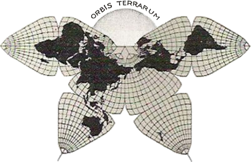
Note the finer mesh of the graticule, as compared to secondary sources (1938, 1944, 1962, 1975) which damn Cahill with faint praise, tiny or botched illustrations, and derisory graticules.

However
, this is not a 5° graticule as it appears at first glance; it is 7 1/2°, a design flaw, in my opinion, stemming from Cahill’s selection of 22 1/2° W for the defining meridian. Waterman’s version (and mine) are drawn with 5° geocells and a 20° W  defining meridian.
Source (print)
B.J.S. Cahill, "An Account of a New Land Map of the World"
(The Scottish Geographical Magazine, 1909-09) p. 449-469
Source (online: page title & link)
http://www.genekeyes.com/Cahill,1909_Butterfly_Map.html
Source (online: item link)
genekeyes.com/Cahill,New_Land_Map_1909/p.464-Cahill_Land_Map_1909.jpg

Go back to Cahill Gallery Thumb Index
Go back to B.J.S. Cahill resource page
Go back to Gene Keyes home page

2007-06-05